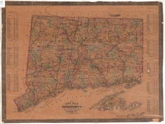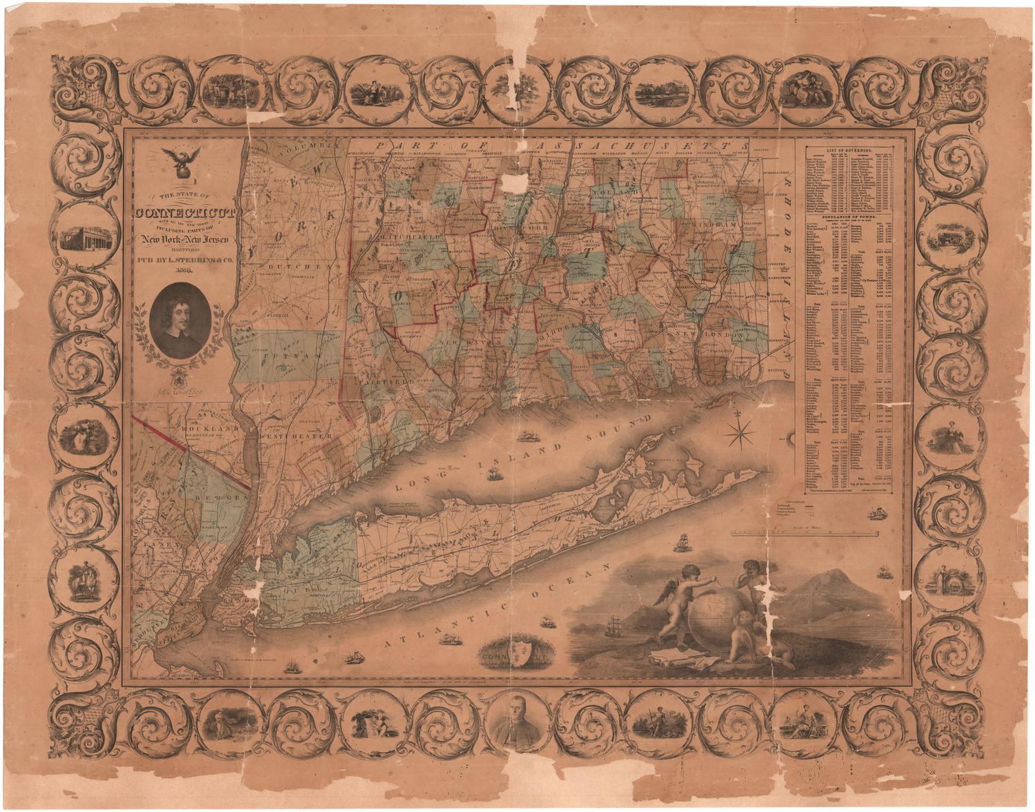
The State of Connecticut with all the New Towns, Including Parts of New York and New Jersey
PublisherPublished by
Lucius Stebbins & Co.
(American, 1858 - 1859)
Date1859
MediumEngraving; black printer's ink and watercolor on wove paper, lined with paper
DimensionsPrimary Dimensions (image height x width): 29 3/8 x 39 1/8in. (74.6 x 99.4cm)
Sheet (height x width): 33 1/4 x 42 5/8in. (84.5 x 108.3cm)
Mount (height x width): 33 1/2 x 42 5/8in. (85.1 x 108.3cm)
ClassificationsGraphics
Credit LineConnecticut Museum of Culture and History collection
Object number1956.91.0
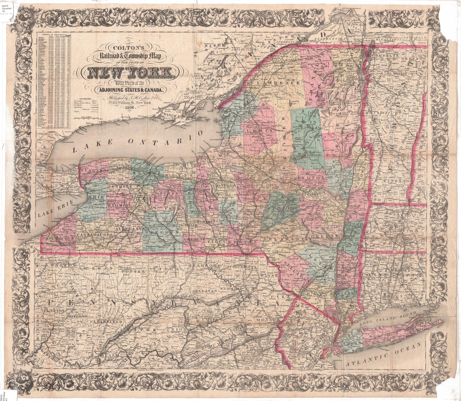
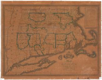
DescriptionMap of Connecticut, the eastern part of New York State, Long Island, and part of New Jersey. The borders of Massachusetts to the north and Rhode Island to the east are also shown. Connecticut towns are depicted, divided with solid lines and colored blue or light brown, and counties are divided with broken solid red lines. Counties in New York State and New Jersey are marked with broken solid lines and are also colored blue or light brown. Elevation is depicted with clusters of peaks. The New York & New Haven; Harlem; New Jersey; Morris & Essex; New York & Erie; Long Island; New Haven, Hartford & Springfield; Danbury & Norwalk; Housatonic; Naugatuck; Hartford, Providence & Fishkill; Willimantic & Palmer; and Norwich & Worcester Railroad lines are depicted. Proposed railroad lines are also shown. On the right is a list of Connecticut governors from 1639 through 1859, and tables of the populations of Connecticut towns.
The cartouche is decorative, featuring an eagle atop a globe. Below the title information is a portrait of John Winthrop, and around the portrait are two acorn- and leaf-laden oak branches. Below this is a shield with a lion on it, and under this is a Latin inscription, "Spes vincit thronum," which translates to, "Hope overcomes the throne." In the bottom right corner is a depiction of three cherubs using a compass on a globe, with drafting materials, a spyglass, and rolls of paper at their feet. To the left of the cherubs is the state shield of Connecticut with the state motto and three grapevines on it, with a cover of grapevines above it. Around the borders are vignettes with allegorical and some historical figures and scenes, Including a portrait of Roger Sherman and the Charter Oak.
The cartouche is decorative, featuring an eagle atop a globe. Below the title information is a portrait of John Winthrop, and around the portrait are two acorn- and leaf-laden oak branches. Below this is a shield with a lion on it, and under this is a Latin inscription, "Spes vincit thronum," which translates to, "Hope overcomes the throne." In the bottom right corner is a depiction of three cherubs using a compass on a globe, with drafting materials, a spyglass, and rolls of paper at their feet. To the left of the cherubs is the state shield of Connecticut with the state motto and three grapevines on it, with a cover of grapevines above it. Around the borders are vignettes with allegorical and some historical figures and scenes, Including a portrait of Roger Sherman and the Charter Oak.
Label TextNo fewer than fifteen towns, including New Britain, West Hartford, Old Lyme, and Old Saybrook, were added to Connecticut during the 1850s, creating a clear need for a new map. Hartford publisher Lucius Stebbins evidently perceived this need, and in 1859, published this map of "The State of Connecticut with all the New Towns." Though by this date, most map publishers were using lithography to reproduce their maps, Stebbins employed the older technique of engraving, the same technique that he would employ for two large pictorial prints of Civil War subjects which he published during the 1860s. Those two engravings were engraved and printed in New York, and Stebbins may also have used a New York engraver and printer for this map.
NotesCartographic Note: Scale: 1 inch equals 5 milesStatus
Not on view