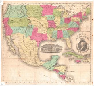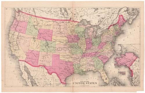
Map of the United States
PublisherPublished by
Unknown
Date1874
MediumLithography; black printer's ink and watercolor on wove paper
DimensionsPrimary Dimensions (image height x width): 12 7/8 x 21 3/4in. (32.7 x 55.2cm)
Sheet (height x width): 14 5/8 x 22 3/4in. (37.1 x 57.8cm)
ClassificationsGraphics
Credit LineMuseum purchase
Object number1980.100.21
DescriptionMap of the United States, with Canada to the north, the Atlantic Ocean to the east, Mexico and the Gulf of Mexico to the south, and the Pacific Ocean to the west. In the bottom right corner is an inset map of Alaska. The states are labeled, divided by broken solid and dotted lines, and colored green, yellow, or one of two shades of pink. Towns are marked with open circles and forts with crosses. Elevation is conveyed with hachure marks. Roads or railroads are shown as single lines but are not labeled.
Label TextThe Connecticut Historical Society acquired this Map of the United States with a lot of maps from an atlas published by Frederick W. Beers. It therefore seems likely, but not certain, that Beers was its publisher. Although F. W. Beers was born in Brooklyn, New York, the Beers family and deep roots in Connecticut and F. W. died in Newtown, Connecticut in 1933. At the time this map was published, Alaska, which appears with the cryptic notation "TO UNITED STATES," was a recent acquisition, having been purchased from Russia in 1867.
NotesCartographic Note: Scale: About an inch equals 150 milesStatus
Not on view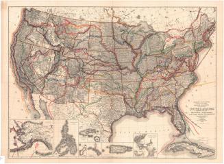
Ithamar P. Berthrong
1908