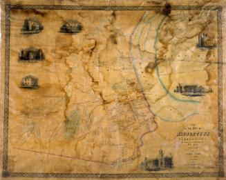
Portland
PublisherPublished by
F. W. Beers & Co.
(American)
Date1874
MediumLithography; black printer's ink and watercolor on wove paper
DimensionsPrimary Dimensions (image height x width): 26 5/8 x 14in. (67.6 x 35.6cm)
Sheet (height x width): 26 7/8 x 14 5/8in. (68.3 x 37.1cm)
ClassificationsGraphics
Credit LineMuseum purchase
Object number1980.100.10
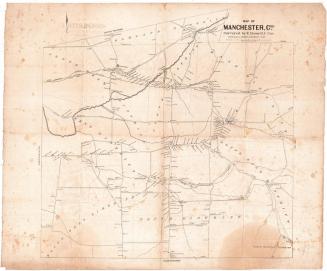
DescriptionMap of the town of Portland, Connecticut, from Indian Hill Avenue to the north, High Street to the east, the Air Line Railroad to the south, and the Connecticut River to the west. Gildersleeve's Landing is labeled as the area near Indian Hill Avenue. Middlesex Quarry, the town quarry, Brainerds & Company Quarry Company quarry and buildings, and the Shaler & Hall Quarry Company quarry are all shown. Private residences, businesses and public buildings are depicted and labeled with the owner or occupant's name.
Label TextQuarrying began in Portland, Connecticut as early as the 1690s. The quarries achieved their greatest prosperity in the latter part of the nineteenth century, when brownstone from Portland played a major role in the building of New York City. Originally part of what became East Hampton, Portland was incorporated as an independent town in 1841. The name itself derived from Portland, England, which was famous for the building stone from its quarries, and relfects the importance of this local industry. The map clearly shows the transportation network used to bring the quarried stone to market. Schooners (sailing vessels) continued to be an important means of shipping stone well into the twentieth century. This map was originally part of an atlas published by F. W. Beers & Co.
NotesCartographic Note: Scale: 1 inch equals 30 rodsStatus
Not on view