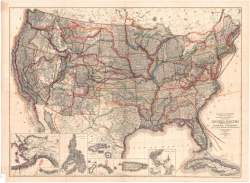
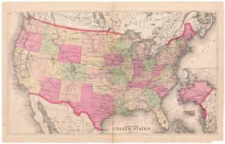
United States Showing Routes of Principal Explorers and Early Roads and Highways
DraftsmanDrawn by
Ithamar P. Berthrong
(American, 1853 - 1936)
MakerBased on data prepared by
Frank Bond
(American, 1856 - 1940)
PrinterPrinted by
Lord Baltimore Press
(American, founded 1898)
PublisherPublished by
United States General Land Office
(American, 1812 - 1946)
Date1908
MediumLithography; black printer's ink and color on wove paper
DimensionsPrimary Dimensions (image height x width): 23 1/2 x 32in. (59.7 x 81.3cm)
Sheet (height x width): 25 1/8 x 34in. (63.8 x 86.4cm)
ClassificationsGraphics
Credit LineGift of the Honorable E. Stevens Henry
Object number1912.4.1
DescriptionMap of the United States, from Canada to the north, the Atlantic Ocean to the east, the Gulf of Mexico to the south, and the Pacific Ocean to the west. Exploration routes are labeled with dates and the explorer's name. Most of the old roads on the map do not have dates (although some do), but are labeled with a brief description of the road's original use: "Old Government Road, " "Great Indian Warriors Path," and "Old Connecticut Path," to name a few. Elevation is conveyed through hachure marks. At the bottom right is a legend with explanations for the symbols and lines that mark Department of the Interior offices and confirmed and unconfirmed land claims. Below the map are insets of Alaska, the Philippines, Guam, Samoa, Hawaii, Puerto Rico and the Panama Canal. Only those of Alaska and Hawaii have exploration routes marked on them.
Label TextThe General Land Office was created in 1812 to oversee the surveying, platting, and sale of public lands in the West. After 1900, the agency began to focus on issuing leases and collecting fees for mineral rights rather than on providing homesteads for settlers. It's unclear why this agency issued this map showing the routes of the early explorers. Frank Bond, who prepared the data on which it was based, had recently become chief clerk of the General Land Office. It may reflect his interests. Certainly the map provides much more detail for the western states than it does for New England. Bond was born in Iowa and began his career as a government surveyor in Wyoming.
NotesCartographic Note: Scale: About 1/4" equals 25 miles for the main map. The insets all have their own scales.Status
Not on view

Southeast Area Transit
