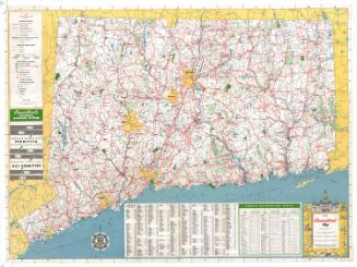
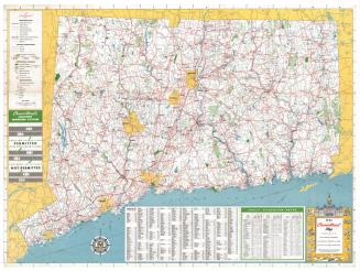
Litchfield County, Connecticut
DraftsmanDrawn by
Vaughn S. Gray
(American, 1911 - 1994)
PublisherPublished by
Vaughn S. Gray
(American, 1911 - 1994)
MakerMade by
Kent Stationery
(American, active late 20th century)
Date1975
MediumLithography; brown and green printer's inks on wove paper
DimensionsPrimary Dimensions (image height x width): 22 x 22in. (55.9 x 55.9cm)
Sheet (height x width): 23 x 23in. (58.4 x 58.4cm)
ClassificationsGraphics
Credit LineMuseum purchase
Object number1980.99.0
DescriptionMap of Litchfield County, Connecticut, from the Massachusetts state line to the north, the Hartford county line to the east, the New Haven and Fairfield county lines to the south, and the New York state line to the west. Towns and cities in the county are labeled, as are such natural features as mountains, ponds, lakes, rivers, and swamps. State parks and forests are denoted in green. Highways and unpaved roads, ski areas, summer camps, camping areas and properties belonging to the Nature Conservancy are also included. The legend, to the bottom left of the map, explains the lines and symbols that represent these features. On the left and right sides of the map are vignettes depicting the Salisbury Town Hall, Gay-Hoyt House, the West Cornwall covered bridge, the Sloane-Stanley Museum, the Kent Memorial Library, the New Milford band stand, the Washington Congregational Church, hte Hitchcock Chair Factory, an example of a turnpike sign, a sketch of the stone walls that line the area, the 1781 mileage marker in Litchfield, the Litchfield Law School, and the Glebe House.
On the verso is a directory of advertisers.
On the verso is a directory of advertisers.
Label TextClearly intended for tourists, this 1975 map of Litchfield County shows historic sites, museums, state parks, forests, camps, and Nature Conservancy properties. Its nostalgic, retrospective look at local attractions may have been inspired in part by the nation's Bicentennial and the wave of cultural tourism that resulted. A picture of Sheldon Tavern in the town of Litchfield notes that Washington stopped there in the "Revolutionary Period." In keeping with the old-time feel of the map, the artist signed himself "Yr. most Humble and Obedt servant, Vaughn Gray."
NotesCartographic Note: Scale: 1/2 inch equals 1 mileStatus
Not on view