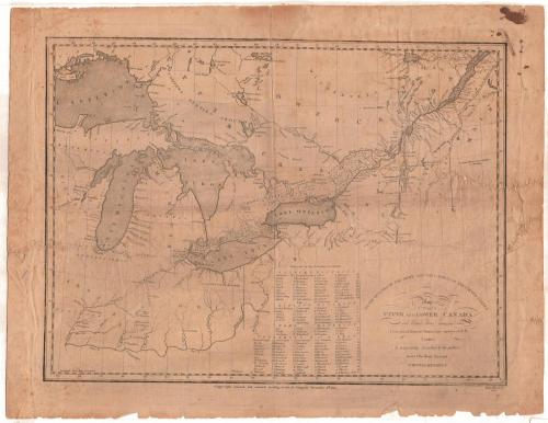
Map of Upper and Lower Canada and United States, contiguous
PrintmakerEngraved by
Thomas Kensett
(American, 1786 - 1829)
After a work byAfter a work by
Pierre Francois Tardieu
(French, 1757 - 1822)
PrinterPrinted by
Thomas Kensett
(American, 1786 - 1829)
PublisherPublished by
Thomas Kensett
(American, 1786 - 1829)
Date1812
MediumEngraving; black printer's ink on wove paper
DimensionsPrimary Dimensions (image height x width): 13 3/4 x 18 1/8in. (34.9 x 46cm)
Platemark (height x width): 15 1/4 x 19 5/8in. (38.7 x 49.8cm)
Sheet (height x width): 16 3/8 x 21 5/16in. (41.6 x 54.1cm)
ClassificationsGraphics
Credit LineConnecticut Museum of Culture and History collection
Object number2012.312.212
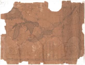
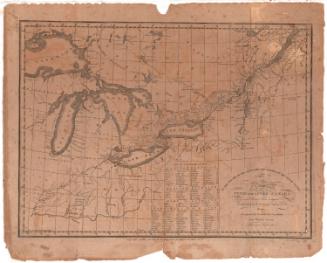
DescriptionMap of what was Upper and Lower Canada, from the wildnerness north of Lower Canada to the north, the border of the United States to the east, the Western Reserve of Connecticut to the south, and Lake Superior to the west. Settlements are shown in districts divided into numbered sections, which correspond to a list of townships that appears below the map. Lakes and rivers are labeled, and width in yards of some of the rivers is provided.
Label TextConnecticut engraver Thomas Kensett's Map of Upper & Lower Canada was issued during the War of 1812 and was dedicated to "the Officers of the Army and the citizens of the United States." Kensett must have hoped that his map would be of use to the American military in planning their campaign against the British as well as to those citizens who wanted to be able to follow and understand the troop movements. It provides a great deal of detail both about the border forts and the Canadian townships, based, Kensett claimed, on "the manuscript surveys of P. F. Tardieu." It is unclear how Kensett, living in rural Cheshire, Connecticut, would have gained access to the original surveys of a French cartographer working in Paris.
NotesCartographic Note: No scaleStatus
Not on view