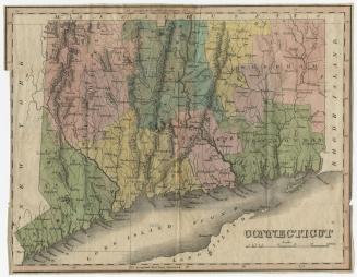
A map of the most inhabited part of New England
DraftsmanDrawn by
W. Dall
(American)
After a work byAfter a work by
Georges Louis LeRouge
(French, 1707 - 1790)
Dateafter 1777
MediumDrawing; Black ink on laid paper
DimensionsPrimary Dimensions (image height x width): 41 3/8 x 18 3/4in. (105.1 x 47.6cm)
Sheet (height x width): 42 3/4 x 19 1/4in. (108.6 x 48.9cm)
ClassificationsGraphics
Credit LineConnecticut Museum of Culture and History collection
Object number2012.312.209
DescriptionPart of a map of New England and part of New York State, with what is now Vermont to the north, the outline of New Hampshire to the east, the Long Island Sound and Long Island to the south, and Part of New York State to the west. Only the outlines of Massachusetts and Connecticut have been completed, although Greenwich and Stamford, Connecticut, have been labeled, and some of the small rivers in the area filled in. Rivers, mountains, bays, harbors, islands and lakes are the natural features depicted. Elevation is shown with clusters of peaks. Dwellings, forts, meeting houses and "Indian habitations" are depicted with symbols defined in the Explanation list.
Label TextThis appears to be an early manuscript copy of a portion of George Louis Le Rouge's Map of the Most Inhabited Part of New England, which itself was based on a British map with the same title, published in London by Thomas Jeffreys in 1774. Neither the identity of the draftsman, W. Dall, or the purpose of the copy are known. It is possible that "Hazzen," who made the surveys of the Hudson River "to Lydius or Nicholson's Fort" could be Moses Hazen (1733-1803), a military officer who led the construction of a military road in Vermont during 1779.
NotesCartographic Note: no scaleStatus
Not on view