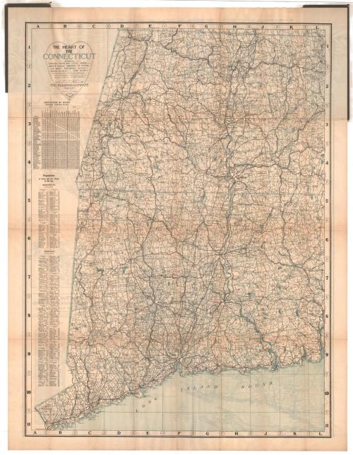
The Heart of the Connecticut
PublisherPublished by
The Bullard Company
(American, 1909 - 1915)
Date1913
MediumLithography; black and blue printer's inks on wove paper
DimensionsPrimary Dimensions (image height x width of .a): 42 1/8 x 31 1/8in. (107 x 79.1cm)
Sheet (height x width of .a): 45 1/8 x 34 5/8in. (114.6 x 87.9cm)
Primary Dimensions (image height x width of .b): 35 x 31 3/4in. (88.9 x 80.6cm)
Sheet (height x width of .b): 45 1/8 x 34 5/8in. (114.6 x 87.9cm)
Sheet (height x width of .a): 45 1/8 x 34 5/8in. (114.6 x 87.9cm)
Primary Dimensions (image height x width of .b): 35 x 31 3/4in. (88.9 x 80.6cm)
Sheet (height x width of .b): 45 1/8 x 34 5/8in. (114.6 x 87.9cm)
ClassificationsGraphics
Credit LineConnecticut Museum of Culture and History collection
DescriptionMap of the Connecticut River Valley in Connecticut and Western Massachusetts, showing through and local roads, churches, schools, cemeteries, railroad stations, light houses and post offices. Altitude in feet is provided, and gradual and steep declines are marked with arrows. To the left of the map is a chart listing the distances between various places in Connecticut and Western Massachusetts. Below this are two population lists for towns in the counties depicted. On the verso is a map of most of New England, from the border of Canada and Bangor, Maine to the north, the Atlantic Ocean to the east, the Long Island Sound to the south, and the eastern part of New York State to the west. It shows roads and railroads. Above the map is an index to the towns and their populations, and in the bottom right corner is a table of distances by rail.
Object number2012.312.208
NotesCartographic Note: Scale (.a) 1 inch equals 3 miles; (.b) 1 inch equals 8 1/2 milesOn View
Not on view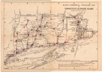
Blum's Commercial Map Publishing Company
1927-1928