Aransas Bay
DraftsmanDrawn by
R. F. Patton
(American, active 1858)
Date1858
MediumDrawing; black and red ink on wove paper
DimensionsPrimary Dimensions (image height x width): 24 1/16 x 36 1/2in. (61.1 x 92.7cm)
Sheet (height x width): 24 3/4 x 37 3/8in. (62.9 x 94.9cm)
ClassificationsGraphics
Credit LineConnecticut Museum of Culture and History collection
Object number2012.312.204
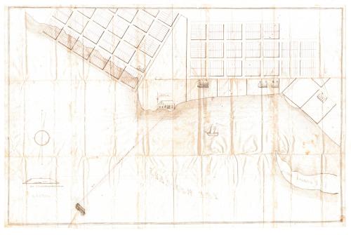
DescriptionManuscript map of Aransas Bay, Texas, and the surrounding land, including Lamar Warehouse. In the waters of the bay, Goose Island is depicted in the lower right corner, and on the left side, a dock or other structure on stilts is shown, with a line leading to the warehouse on land. The line is labeled, "Proposed Road." To the left of the drawing is a diagram of the road with its dimensions, including elevation. Sections of land are divided into what are probably house lots, with five houses or other dwelling places depicted. On the left side, the water appears to cover part of the land. In the center is a triangular piece of land with no divisions, at the bottom of which is the Lamar Warehouse. The land is labeled with, "Reservation by & for the proprietors
Label TextJames W. Byrne, a native of Ireland and a veteran of the Texas Revolution, established the town of Lamar, Texas, on Aransas Bay in 1838. Beginning in 1856, he conveyed large parcels of land in the area to Hartford gun-manufacturer Samuel Colt, perhaps hoping that Colt would establish a gun factory on the Texas Coast. This manuscript map was included in a letter that Byrne sent to Colt in 1858. The last transaction between Bryne and Colt apparently took place on April 2, 1861, barely ten days before the bombardment of Fort Sumter. Colt died in 1862 without ever visiting Texas. Byrne died in 1865.
NotesCartographic Note: No scaleStatus
Not on view