
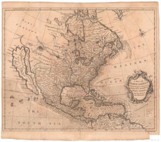
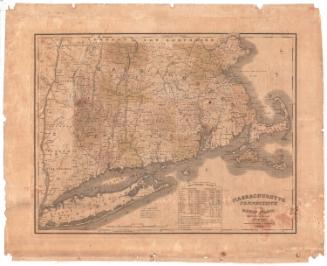
Map of the Proposed Northern Route for a Railroad to the Pacific
DraftsmanDrawn by
Edwin F. Johnson
(American, 1803 - 1872)
PrinterLithographed by
E.C. Kellogg & Co.
(American, 1851 - 1854)
Date1853
MediumLithography; black printer's ink on wove paper
DimensionsPrimary Dimensions (image height x width): 20 5/8 x 32 5/8in. (52.4 x 82.9cm)
Sheet (height x width): 22 x 34 7/8in. (55.9 x 88.6cm)
ClassificationsGraphics
Credit LineConnecticut Museum of Culture and History collection
Object number2012.312.202
DescriptionMap of the United States and part of Canada, primarily depicting a proposed railroad line from Chicago to Bellingham Bay, Washington. Other westward-bound railroad lines are shown, including one from Chicago to Astoria, Oregon; from Memphis to San Francisco; from New Orleans to San Diego; and from St. Louis to Walker's Pass, California. Direct routes between two places are denoted with broken solid lines. Physical features depicted include elevation, conveyed with hachure marks; lakes, rivers, islands, bays and gulfs.
Label TextThe prominent civil engineer, Edwin F. Johnson lived most of his life in Middletown, Connecticut, where he established the first department of civil engineering in the country at the military school that was the precursor of Wesleyan University. Johnson was not just a teacher, however; he was a practical engineer who worked on many early railroads, including the New York & Boston Air Line Railroad. As early as 1840, he was advocating a railroad to the West, crossing the Mississippi River at Rock Island, Illinois. In 1853, he published a pamphlet recommending the route later developed by the Northern Pacific Railroad, of which he eventually became chief engineer. The Northern Pacific was still under construction when Johnson died in 1872.
NotesCartographic Note: Scale: About 1/2 inch equals about 50 milesStatus
Not on view


H. F. Sumner & Co.
1833