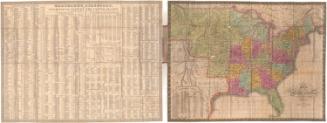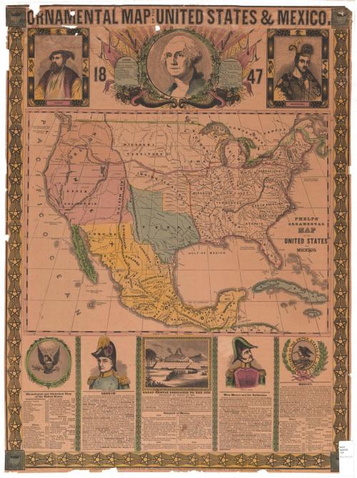
Ornamental Map of the United States & Mexico
PublisherPublished by
Humphrey Phelps
(American, 1799 - 1875)
Date1847
MediumLithography; black printer's ink and watercolor on wove paper
DimensionsPrimary Dimensions (image height x width): 28 3/8 x 21in. (72.1 x 53.3cm)
Sheet (height x width): 28 5/8 x 21 1/4in. (72.7 x 54cm)
Sheet (height x width): 28 5/8 x 21 1/4in. (72.7 x 54cm)
ClassificationsGraphics
Credit LineConnecticut Museum of Culture and History collection
DescriptionMap of the United States, Mexico, part of Guatemala and part of the Caribbean islands, from the border of Canada to the north, the Atlantic Ocean to the east, Guatemala to the south, and the Pacific Ocean to the west. Relief is conveyed through hachure marks. The bottom and sides are decorated with a border of stars linked by chains, and at all four corners, there is a shield featuring stars and stripes.
Along the top of the sheet, right below the title, there are three vignettes, with images of Cortez and Montezuma flanking a larger portrait of Washington. The frames around Cortez and Montezuma contain various symbols: volcanos, shells, stars, suns, flags and eagles. Around Washington's portrait are mirror images featuring leafy oak branches laden with acorns, cornucopias or horns of plenty, liberty caps, and the American flag. On the right side of the portrait are a banner that says "Liberty" and a list of facts about Montezuma; on the left, there are a banner that says "Justice" and a list of facts about Cortez.
Below the map, there are five more vignettes. At the far left is a list entitled, "Chronological and Statistical View of the United States," which contains dates of settlements and notable events up to 1846, as well as statistics on population, soldiers, money, slaves, and more. Next to it is a portrait of General Taylor above a block of text titled, "Oregon," which describes the Oregon Territory. In the center there is an image of Templo Mayor, an Aztec temple, with text describing its physical features and use, below which is information about the conquest of Mexico from 1519-1521. Second from the right is a portrait of Santa Anna and text about New Mexico and the Californias. On the far right is the seal of Mexico and information geographical, historical and statistical information about the country.
Object number2012.312.201
NotesCartographic Note: No scaleOn View
Not on view