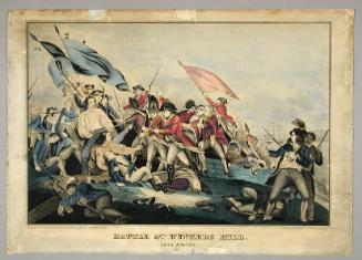
A Plan of the Town and Harbour of Boston
PrinterPrinted by
Meriden Gravure Company
(American, 1888 - 1977)
Date1963
MediumCollotype; black printer's ink and watercolor on paper
DimensionsPrimary Dimensions (image height x width): 14 3/8 x 18 7/8in. (36.5 x 47.9cm)
Sheet (height x width): 17 1/4 x 21 3/4in. (43.8 x 55.2cm)
ClassificationsGraphics
Credit LineConnecticut Museum of Culture and History collection
Object number1964.66.0
DescriptionReproduction of a map of Boston, depicting the locations of the British and American troops in battles at Lexington and Concord and Bunker Hill, the army encampments, and the positions of ships in the harbor. The routes of the Minutemen, shown in blue coats and carrying rifles, are delineated at the top of the map. Below the title on the left side, there is a list of references that correspond to numbers found on the map, most of them clustered in and around the harbor area, that describe the ships, forts, batteries and events of the battles.
Label TextThis reproduction of a map showing Boston in 1775 was printed by the Meriden Gravure Company of Meriden, Connecticut. Though the Connecticut Historical Society does not own the original map, this facsimile forms part of its collections of fine printing by Connecticut printers. From 1888 until 1977, the Meriden Gravure Company specialized in high-quality image reproduction for academic institutions, museums, and libraries. The Connecticut Historical Society itself was among its customers, and CHS has many other examples of its work in its collections.
NotesCartographic Note: No scaleSubject Note: The engagement that we now refer to as the Battle of Bunker Hill is simply identified as "the battle of 17th June 1775."
Status
Not on view