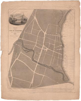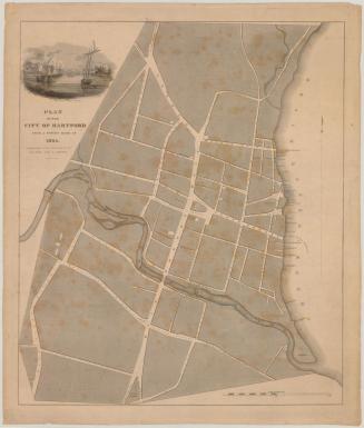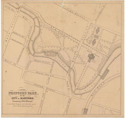
Proposed Park, for the City of Hartford, Containing about 30 acres
DraftsmanDrawn by
Seth E. Marsh
(American, about 1823 - 1878)
Date1858
MediumLithography; black printer's ink on wove paper
DimensionsPrimary Dimensions (image height x width): 18 1/16 x 19 3/8in. (45.9 x 49.2cm)
Sheet (height x width): 19 x 23 3/4in. (48.3 x 60.3cm)
ClassificationsGraphics
Credit LineGift of Helen Mitchell
Object number1989.159.3
DescriptionMap of Hartford, Connecticut, oriented upside down on the map so that north and south are reversed, from College Street at the top of the sheet and Asylum Street at the bottom. It shows a proposal for what would become Bushnell Park, with the State House at the intersection of Elm and Bliss Streets and Trinity College at Bliss, College and Washington Streets. A fountain is depicted along the Little or Park River, with several footbridges across the river to Mill Street.
Label TextBushnell Park in Hartford,Connecticut was the first publicly financed urban park in the nation. Hartford voters approved the expenditure of public funds for the purchase of land for the park in January 1854, but by 1858, the park had not yet begun to take shape. In that year, the Common Council held a competition for the design of the park, in which Gervase Wheeler of New York City won first prize and Seth Marsh, Hartford's city surveyor, won second prize. This map probably represents Marsh's second prize design. Neither plan was executed and it was not until 1861 that Jacob Weidenmann, a Swiss-born landscape architect was finally hired to design and build the park.
NotesCartographic note: No scaleStatus
Not on view