Novi Belgii, quod nunc Novi Jorck
PublisherPublished by
Arnoldus Montanus
(Dutch, 1625 - 1683)
Date1671
MediumEngraving; printer's ink on laid paper
DimensionsPrimary Dimensions (image height x width): 11 3/8 x 14 3/8in. (28.9 x 36.5cm)
Platemark (height x width): 11 1/2 x 14 1/2in. (29.2 x 36.8cm)
Sheet (height x width): 12 1/8 x 14 3/4in. (30.8 x 37.5cm)
ClassificationsGraphics
Credit LineThe Newman S. Hungerford Museum Fund
Object number2012.172.2
DescriptionMap of the east coast of the United States, from Chesapeake Bay to Quebec, with the St. Lawrence River to the north, the mythical Norumbega to the east, the Atlantic Ocean to the south, and the Delmarva Peninsula and points north to the west. The names of Native American tribes and their locations are prominent on the map. Forts and settlements are marked with symbols and names. Geographic features include elevation, conveyed through depictions of shaded mountains; forests, denoted as clusters of trees; rivers, islands, bays and sandbars. Bears, deer, turkeys, beavers and rabbits appear scattered across the land. The title cartouche shows Native American scenes, featuring a wigwam settlement, hunting, exploration in a canoe, and two standing figures, one with a bow and the other holding a chisel-type tool against a large rectangular block. A compass rose with a north arrow appears in the part of the Atlantic Ocean south of Long Island.
Label TextThis map is an illustration from De Nieuwe en Onbekende Weereld (The New and Unknown World), a 1671 account of America by the Dutch scholar Arnoldus Montanus. While Montanus acknowledges that New Amsterdam is now New York, the Dutch having relinquished their claims to the English in 1667, the Dutch would make one more attempt to regain their lost colony, in 1673. Dutch names naturally predominate on the map, making the English settlements along the Connecticut coast and the Connecticut River difficult to recognize: Nieuhaven is New Haven; Guilfort, Stratfort, Stamfort, and Hertfort are Guilford, Stratford, Stamford, and Hartford. Weetersvelt is Wethersfield, and Voynser is Windsor. Native American tribes are prominantly shown and occupy a large portion of the map both around the English settlements and in the hinterlands. The Pequot War had taken place barely thirty years earlier; King Philip's War still lay four years in the future at the time this map was published.
NotesCartographic Note: The scale shows measurements in increments of 5, from 0-15, and is accompanied by the phrase "Milliaria Germanica communia"Status
Not on view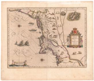


H. F. Sumner & Co.
1833