A Chart of the World
PublisherPublished by
Hutchinson & Dwier
(American, 1834 - 1836)
Date1834
MediumEngraving; black printer's ink and watercolor on paper, lined with linen
DimensionsPrimary Dimensions (image height x width): 17 1/2 x 21 3/16in. (44.5 x 53.8cm)
Platemark (width only): 23 1/2in. (59.7cm)
Sheet (height x width): 22 1/8 x 25 7/8in. (56.2 x 65.7cm)
Mount (height x width): 22 1/8 x 25 7/8in. (56.2 x 65.7cm)
Other (Rollers): 22 3/8 x 31 1/2in. (56.8 x 80cm)
Platemark (width only): 23 1/2in. (59.7cm)
Sheet (height x width): 22 1/8 x 25 7/8in. (56.2 x 65.7cm)
Mount (height x width): 22 1/8 x 25 7/8in. (56.2 x 65.7cm)
Other (Rollers): 22 3/8 x 31 1/2in. (56.8 x 80cm)
ClassificationsGraphics
Credit LineThe Newman S. Hungerford Museum Fund
DescriptionMap of the world, depicting all of the continents except Antarctica. Countries are depicted, labeled and divided by broken solid lines, with cities denoted by circles. Color is used to show the spread of the following religions: Protestant, Roman Catholic, Greek Church, "Mahometanism," and "Paganism." Missionary stations are denoted with crosses. A table below the map, titled "Extent and Population," provides the size in square miles and population of Europe, Asia, Africa, North and South Americas, and Polynesia.
Five vignettes appear below the map depicting scenes meant to represent the Protestant, Muslim, pagan, Roman Catholic and Jewish religions. Below this is a table, titled, "A Chart Exhibiting the Progress of Christianity from the birth of our Saviour to the Present time," that shows the incidence of Christianity versus paganism in the countries of Europe, Asia, Africa, South America and North America, from AD 100 to 1800.
Five vignettes appear below the map depicting scenes meant to represent the Protestant, Muslim, pagan, Roman Catholic and Jewish religions. Below this is a table, titled, "A Chart Exhibiting the Progress of Christianity from the birth of our Saviour to the Present time," that shows the incidence of Christianity versus paganism in the countries of Europe, Asia, Africa, South America and North America, from AD 100 to 1800.
Object number2011.507.0
NotesCartographic Note: No scaleOn View
Not on view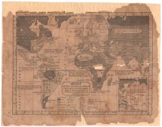


N. & S. S. Jocelyn
1825