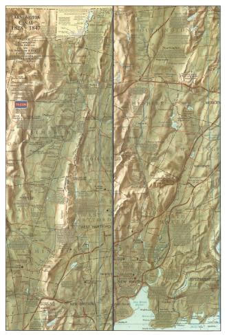
Map of the Hampshire and Hampden Canal
MakerCompiled by
Carl E. Walter
(American, born 1938)
Date2006
MediumOffset lithography; black and colored printer's inks on paper
DimensionsPrimary Dimensions (left side, image height x width): 24 x 17in. (61 x 43.2cm)
Primary Dimensions (right side, image height x width): 24 x 19in. (61 x 48.3cm)
Sheet (height x width): 24 1/4 x 36 1/4in. (61.6 x 92.1cm)
Primary Dimensions (right side, image height x width): 24 x 19in. (61 x 48.3cm)
Sheet (height x width): 24 1/4 x 36 1/4in. (61.6 x 92.1cm)
ClassificationsGraphics
Credit LineGift of Carl E. Walter
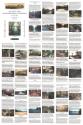
DescriptionMap of the Hampshire and Hampden Canal in Massachusetts, split into two sections and overlaid onto later topographical maps of the area. On the left is the canal as it flowed from Northampton to Southampton, with Holyoke and the Connecticut River to the east. On the right is the canal as it flowed through Westfield county to the state line of Connecticut. The canal is color-coded for which parts remained as of 2006, when the map was published, and which are gone. Locks, culverts, drains and other structures along the canal are labeled, with a brief description of the objects. These, too, are color-coded for which structures remain and which do not. On the right side of each map is a profile of the canal. Various facts about the canal are scattered across the map. The verso contains "historical vignettes" describing the history of the canal as it ran through various places in Massachusetts. The text is accompanied by images depicting some aspect of the canal in each town.
Object number2012.455.2
NotesCartographic Note: Scale: 2 inches equals 1 mileOn View
Not on view