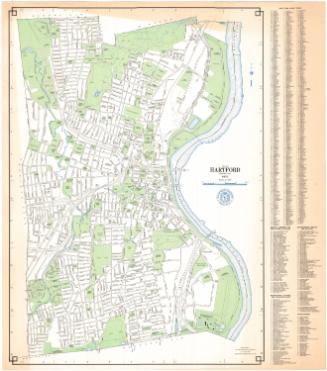
Hartford
PublisherPublished by
Baker & Tilden
(founded 1869)
Date1869
MediumLithography; black printer's ink and watercolor on wove paper
DimensionsPrimary Dimensions (image .a height x width): 27 x 16 3/4in. (68.6 x 42.5cm)
Primary Dimensions (image .b height x width): 8 1/2 x 5 3/8in. (21.6 x 13.7cm)
Sheet (height x width): 27 7/8 x 17 3/4in. (70.8 x 45.1cm)
Primary Dimensions (image .b height x width): 8 1/2 x 5 3/8in. (21.6 x 13.7cm)
Sheet (height x width): 27 7/8 x 17 3/4in. (70.8 x 45.1cm)
ClassificationsGraphics
Credit LineConnecticut Museum of Culture and History collection
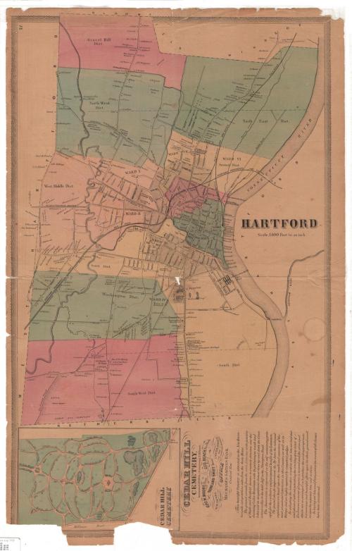
DescriptionMaps of Hartford, Connecticut (.a), and Cedar Hill Cemetery (.b) in Hartford, printed on the same sheet. The map of Hartford is much larger than the other one. The city is divided into Wards 1-5, and the Gravel Hill District, North West District, North East District, West Middle District, North Middle District, Centre District, South District, Washington District, South District and South West District. It extends from the town lines of Bloomfield and Windsor to the north, the town line of East Hartford to the east, the town line of Wethersfield to the south, and the town line of West Hartford to the west. The Connecticut River divides Hartford from East Hartford, and the Park and Hockanum Rivers join it. The North and South Forks of the Park River are also depicted on the map. The Hartford, Providence and Fishkill and the Hartford and New Haven Railroads run east-west through the city. The names of property owners or occupants are listed next to small squares denoting the location of the property. Notable landmarks include Trinity College, Bushnell Park (referred to as "The Park" on the map), various cemeteries, the Deaf and Dumb Asylum, the Hartford Orphan Asylum, and Sharps Rifle Manufacturing Company.
Below the main map of Hartford there is a smaller map of Cedar Hill Cemetery and several paragraphs of text about it. The cemetery extends from North Side Avenue to the north, Maple Avenue and the main entrance to the east, Hillhouse Road to the sotuh, and Intervalue Avenue to the west. It is divided into 24 numbered sections, and its lakes and winding roads are included in the map.
Below the main map of Hartford there is a smaller map of Cedar Hill Cemetery and several paragraphs of text about it. The cemetery extends from North Side Avenue to the north, Maple Avenue and the main entrance to the east, Hillhouse Road to the sotuh, and Intervalue Avenue to the west. It is divided into 24 numbered sections, and its lakes and winding roads are included in the map.
Object number2012.312.198
NotesCartographic Note: Scale, map of Hartford: 1 inch equals 1400 feet; no scale on map of Cedar Hill CemeteryOn View
Not on view