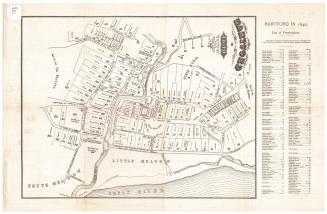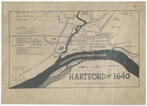
Hartford of 1640
DraftsmanDrawn by
Claude L. Yates
(American, 1890 - 1945)
After a work byAfter a work by
William S. Porter
(American, about 1800 - 1866)
PrinterPrinted by
Unknown
Date1928
MediumPhotography; photostat on paper
DimensionsPrimary Dimensions (image height x width): 6 3/4 x 11 1/4in. (17.1 x 28.6cm)
Sheet (height x width): 8 7/8 x 12 1/2in. (22.5 x 31.8cm)
ClassificationsGraphics
Credit LineConnecticut Museum of Culture and History collection
Object number2012.312.196
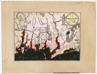
DescriptionMap of Hartford as it appeared in 1640, oriented east-west on the sheet, with the north arrow pointing to the right side of the map. The city extends from Soldier's Field to the north, the Connecticut or Great River to the east, the ox pasture to the south, and the old ox pasture to the west. The locations of only three private residences are listed: Governor Wyllys' house, Samuel Stone's house, and Thomas Hooker's house. Public spaces include the meeting house and yard, the jail, the first church school, and the town common. There are quite a few small pictures representing various features of Hartford that are explained with inscriptions: the location of the Charter Oak, the Dutch fort, a Native American village, a stand of cherry trees, the first Dutch ship ("Onrest"), and more. Of the streets depicted, two of them are labeled with their names in 1928.
Label TextArtist Claude L. Yates claimed that he prepared his map, Hartford of 1640, from "Old Maps, Records, etc." but his principal source was clearly William S. Porter's important map, Hartford in 1640, prepared in 1838. Yates adds much more anecdotal information to his map, including the Indian Sweat House, Wolf Pound, and an Indian Village and Fort. The ship "Onrust," which Henry Hudson was sailing when he discovered Hartford is shown at Dutch Point, even though the discovery took place in 1614, so the ship would not have been present in 1640, the year supposedly depicted in the map. In 1929, a year after he made this map, Yales presented a large relief map of Hartford to the Hartford Grade School Teachers Club. It seems likely that Hartford of 1640 is a preparatory study for the relief map, which included "spots of interest relating to the Indians, Dutch, and English" and was to be used in the teaching of history.
NotesCartographic Note: No scaleMedium Note: The Photostat machine, invented in the early 1900s, used a large camera to produce a negative photographic print in less than two minutes. This print could then be used to produce multiple copies. The process remained in use through the 1940s.
Status
Not on view