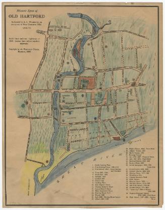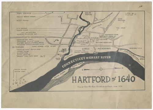
Hartford of 1640
DraftsmanDrawn by
Claude L. Yates
(American, 1890 - 1945)
After a work byAfter a work by
William S. Porter
(American, about 1800 - 1866)
PrinterPrinted by
Unknown
Date1928
MediumPhotography; photostat on paper
DimensionsPrimary Dimensions (image height x width): 6 3/4 x 11 1/4in. (17.1 x 28.6cm)
Sheet (height x width): 8 7/8 x 12 1/2in. (22.5 x 31.8cm)
Sheet (height x width): 8 7/8 x 12 1/2in. (22.5 x 31.8cm)
ClassificationsGraphics
Credit LineConnecticut Museum of Culture and History collection
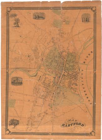
DescriptionMap of Hartford as it appeared in 1640, oriented east-west on the sheet, with the north arrow pointing to the right side of the map. The city extends from Soldier's Field to the north, the Connecticut or Great River to the east, the ox pasture to the south, and the old ox pasture to the west. The locations of only three private residences are listed: Governor Wyllys' house, Samuel Stone's house, and Thomas Hooker's house. Public spaces include the meeting house and yard, the jail, the first church school, and the town common. There are quite a few small pictures representing various features of Hartford that are explained with inscriptions: the location of the Charter Oak, the Dutch fort, a Native American village, a stand of cherry trees, the first Dutch ship ("Onrest"), and more. Of the streets depicted, two of them are labeled with their names in 1928.
Object number2012.312.196
NotesCartographic Note: No scale
Medium Note: The Photostat machine, invented in the early 1900s, used a large camera to produce a negative photographic print in less than two minutes. This print could then be used to produce multiple copies. The process remained in use through the 1940s.On View
Not on view