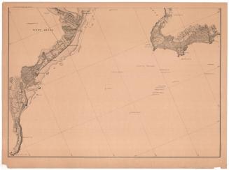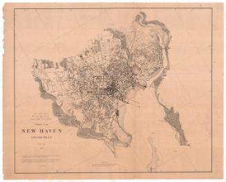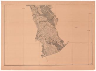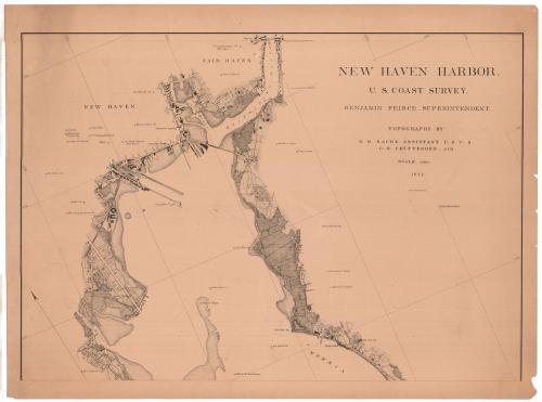
New Haven Harbor
SurveyorSurveyed by
Richard Meade Bache
(American, 1830 - 1907)
SurveyorSurveyed by
George Benjamin Chittenden
(American, 1849 - 1939)
PrinterLithographed by
Julius Bien
(1826 - 1909)
PublisherPublished by
United States Coast Survey
(American, founded 1807)
Date1872
MediumLithography; black printer's ink on wove paper
DimensionsPrimary Dimensions (image height x width): 21 3/16 x 30 3/8in. (53.8 x 77.2cm)
Sheet (height x width): 24 x 32 1/8in. (61 x 81.6cm)
ClassificationsGraphics
Credit LineConnecticut Museum of Culture and History collection
Object number2012.312.190.1
DescriptionMap of the New Haven, Connecticut, harbor and the land around it, from Fair Haven to the north, the East Haven spire to the east, the harbor to the south, and the West River to the west. The Mill and Quinnipiac Rivers are shown near the top of the map. Some of the city streets are laid out but not labeled, and buildings, presumably including dwellings and businesses, are indicated with black rectangles. Notable man-made features and landmarks, such as cupolas, signal towers, churches and City Hall are marked and labeled. A variety of lines indicates different types of and uses for land, none of which are explained. In the water part of the map, signals, buoys, the long wharf light and a watch house are marked and labeled. Water depth is not included.
Label TextThe city of New Haven is located on a large harbor formed by the confluence of the Quinnipiac, the Mill River, and the West River. The outer harbor is four miles wide, and the city is located about four miles from its entrance. The shallow water of the harbor was a problem; New Haven was a major port during the 1800s and traffic in and out of the harbor was heavy. George Benjamin Chittenden, known as Ben Chittenden, a local boy from nearby Madison, Connecticut, is credited as an "aid" in the inscription on this chart. Chittenden may still have been an undergraduate studying engineering at Yale at the time. Following graduation, he went to work for United States Geological and Geographical Survey of the Territories under Ferdinand V. Hayden. A mountain in Yellowstone National Park is named after him.
NotesCartographic Note: Scale: 1/10,000Status
Not on view