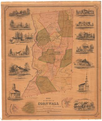
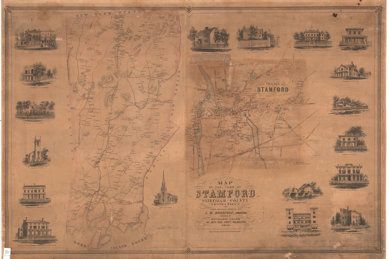
Map of the Town of Woodbury, Litchfield County, Connecticut, from actual Surveys by L. Fagan
SurveyorSurveyed by
L. Fagan
(American, born about 1825)
PublisherPublished by
Richard Clark
(American)
PrinterPrinted by
Wagner & McGuigan
(American, 1845 - 1859)
Date1853
MediumLithography; black printer's ink and watercolor on paper
DimensionsPrimary Dimensions (image height x width): 38 1/8 x 49 3/4in. (96.8 x 126.4cm)
Sheet (height x width): 41 1/2 x 51 1/2in. (105.4 x 130.8cm)
ClassificationsGraphics
Credit LineConnecticut Museum of Culture and History collection
Object number2012.312.184
DescriptionPhysical and political map of Woodbury, Connecticut, from Bethlehem to the north, Watertown to the east, New Haven County to the south, and Roxbury to the west. The fourteen numbered districts and the Good Hill District of Woodbury are labeled, as are villages and smaller settlements. The entire town has an interior outline of pink, and the districts are outlined in blue or pink, and shaded light pink, pale orange, or are left uncolored. Elevation is denoted with hachure marks; forests with clusters of trees; and bodies of water with blue shading. Buildings are marked and in many cases, labeled. Roads are marked but not labeled. To the right of the town map, there are two smaller inset maps of Hotchkissville and Woodbury that show the streets in greater detail, with building and owners labeled.
Around the map there are vignettes showing the residences, churches and industrial buildings of parts of the town of Woodbury, clockwise from top left: the residence of C.J. Minor in Woodbury; the residence of Reubin H. Hotchkiss in Hotchkissville; the residence of the Honorable Charles B. Phelps in Woodbury; the residence and store of Lewis Judd, Esq., in Woodbury; the Parsonage House of Reverend Anthony Stoddard in Woodbury; the residence of R.C. Lawson in Woodbury, the town hall in Woodbury; the residence of J. Abernethy in Hotchkissville; the residence of N.B. Smith in Woodbury; the Hotchkiss Manufacturing Company in Hotchkissville; the North Congregational Church; the residence of Asahel Tyler in Good Hill; the Masonic Hall in Woodbury; St. Paul's Church in Woodbury; the South Congregational Church in Woodbury; Woodbury Academy; South Academy in Woodbury;the residence of Gervase Hotchkiss in Hotchkissville; Turkey Mills in Hotchkissville; the Methodist Episcopal Church in Woodbury; J&R Hotchkiss' cashmere factory in Hotchkissville; the residence of David C. Bacon, Esq., in Woodbury; the residence of William B. Hotchkiss, in Hotchkissville; the residence of Mrs. N.B. Benedict in Woodbury; the residence of W. Cothren, Esq., in Woodbury; and the residence of Josiah Hotchkiss in Hotchkissville.
Around the map there are vignettes showing the residences, churches and industrial buildings of parts of the town of Woodbury, clockwise from top left: the residence of C.J. Minor in Woodbury; the residence of Reubin H. Hotchkiss in Hotchkissville; the residence of the Honorable Charles B. Phelps in Woodbury; the residence and store of Lewis Judd, Esq., in Woodbury; the Parsonage House of Reverend Anthony Stoddard in Woodbury; the residence of R.C. Lawson in Woodbury, the town hall in Woodbury; the residence of J. Abernethy in Hotchkissville; the residence of N.B. Smith in Woodbury; the Hotchkiss Manufacturing Company in Hotchkissville; the North Congregational Church; the residence of Asahel Tyler in Good Hill; the Masonic Hall in Woodbury; St. Paul's Church in Woodbury; the South Congregational Church in Woodbury; Woodbury Academy; South Academy in Woodbury;the residence of Gervase Hotchkiss in Hotchkissville; Turkey Mills in Hotchkissville; the Methodist Episcopal Church in Woodbury; J&R Hotchkiss' cashmere factory in Hotchkissville; the residence of David C. Bacon, Esq., in Woodbury; the residence of William B. Hotchkiss, in Hotchkissville; the residence of Mrs. N.B. Benedict in Woodbury; the residence of W. Cothren, Esq., in Woodbury; and the residence of Josiah Hotchkiss in Hotchkissville.
Label TextWoodbury in the twenty-first century is a small country town known for its numerous antique shops, but in the mid-nineteenth century it was a bustling center of activity, with the mills in Hotchkissville in full swing. A large, elaborate map such as this one would never have been made if there had not been enough local interest to support it. Lawrence Fagan, who surveyed and drew this map of Woodbury, was apparently a native of Ireland who emigrated to the United States about 1850; he also mapped towns and counties in New York and Pennsylvania, as well as other towns in Connecticut. Most of these maps were printed and published in Philadelphia, a major center of lithographic printing during this period.
NotesCartographic Note: Scale on main map: 1 inch equals 80 perches. On map of Woodbury: 1 inch equals 40 perches. On map of Hotchkissville, 1 inch equals 40 perchesStatus
Not on view