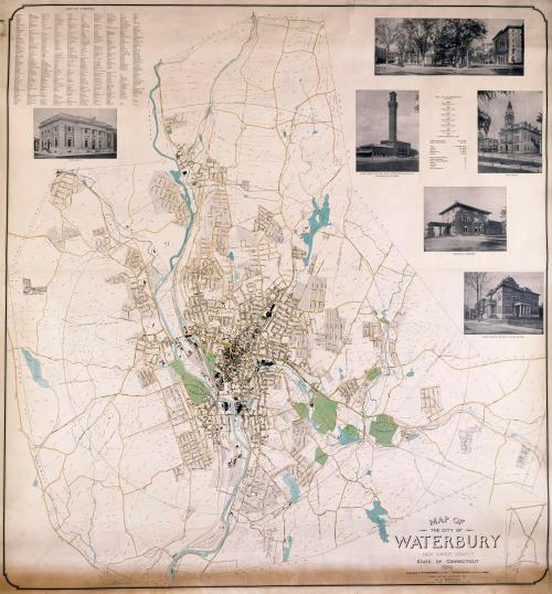
Map of the City of Waterbury
SurveyorSurveyed by
Arthur J. Patton
(American, 1857 - 1934)
PrinterPrinted by
Unknown
PublisherPublished by
A. J. Patton Co.
(American, founded 1914)
Dateabout 1932
MediumLithography; black and colored printer's ink on paper
DimensionsPrimary Dimensions (image height x width): 60 3/4 x 59 1/8in. (154.3 x 150.2cm)
Sheet (height x width): 66 7/8 x 59 5/8in. (169.9 x 151.4cm)
ClassificationsGraphics
Credit LineConnecticut Museum of Culture and History collection
Object number2012.312.180
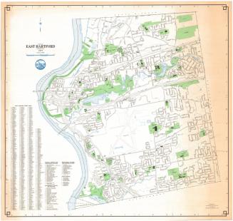
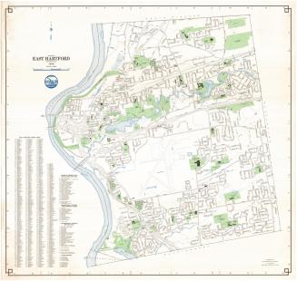
DescriptionStreet map of Waterbury, Connecticut, extending from the town line of Plymouth to the north, the town line of Wolcott to the east, the town line of Prospect to the south, and the town lines of Middlebury and Watertown to the west. The streets and lots are labeled with names and numbers, respectively. Neighborhoods are also labeled with their names. Estates, land owned by companies, and larger lots are labeled with the name of the owner and the number of acres. Parks and cemeteries are colored green, roads are yellow, bodies of water are colored teal or blue-green, and hospitals and industrial buildings are red. There are concentric circles radiating from the center of the city. To the top left, there is a list of mayors, public schools, sectarian and private schools, public buildings, factories, churches and fire stations. To the top right is a street index, and below it, there is information about the population and grand list of Waterbury from 1853 - 1930. Below this, there is a subdivision index. At the bottom left, there is a list titled, "Elevations Above Tide Water At New Haven."
Label TextWaterbury surveyor Arthur J. Patton produced the original survey on which this map was based, but by 1932, when it was probably published, he was seventy-five years old, so it probably was updated by other members of his firm, A. J. Patton Co. The map is dominated by the Naugatuck River and the Hartford, New Haven & New York Railroad, which runs parallel to it. Like the other industrial towns that grew up along the Naugatuck River, Waterbury relied on the river's rushing waters to power its factories and the adjoining railroad to ship its goods. Known as the "Brass City," Waterbury dominated the American brass industry throughout the first half of the twentieth century. By 1932, Chase Brass, the largest of the Waterbury brass manufacturers, had already begun to acquire mid-Western plants. Eventually the business would move west to Ohio.
NotesCartographic Note: No scale given.Status
Not on view