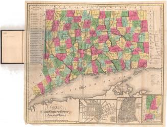
Map of the County of New Haven, Connecticut
SurveyorSurveyed by
R. Whiteford
(American)
PrinterPrinted by
Wagner & McGuigan
(American, 1845 - 1859)
PublisherPublished by
A. Budington
(American)
PublisherPublished by
R. Whiteford
(American)
Date1852
MediumLithography; black printer's ink and watercolor on paper
DimensionsPrimary Dimensions (image height x width): 39 1/4 x 52 3/4in. (99.7 x 134cm)
Sheet (height x width): 42 5/8 x 54 5/8in. (108.3 x 138.7cm)
ClassificationsGraphics
Credit LineConnecticut Museum of Culture and History collection
Object number2012.312.178
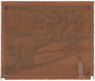
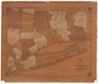
DescriptionPhysical and political map of New Haven County, Connecticut, from the borders of Litchfield and Hartford Counties to the north, Middlesex County to the east, Long Island Sound to the south, and Fairfield County to the west. Plans of Meriden, Waterbury and New Haven are inset on the top and right; below them, there is a table of statistics, with population, area, industrial products and the number of public schools in twenty-four of the towns on the map. Town boundaries are denoted with broken and dotted lines, and are outlined in blue, yellow or pink. Several of the towns are bordered in blue and are a much lighter color than the rest. Physical features marked are elevation, denote with hachure lines; trees or forests; rivers; lakes; and islands. The New York and New Haven, New Haven and New London, New Haven and Springfield, Naugatuck and Canal Railroads are indicated. There is an eight-point compass rose and north arrow. A single vignette shows a view of the State House in New Haven.
The borders of the map are decorative, with a design of grapes and leaves comprising the edges, and rosettes in the corners. The cartouche features an eagle, grasping an olive branch and arrows in its talons, perched atop the Great Seal of the State of Connecticut, which features three grapevines and the Latin motto, "Qui sust trans." To the left of the eagle and seal there is a cornucopia or horn of plenty, a sickle, the handle of what is probably a plow and a bale of grain. A cannon, scales, a scroll and what appear to be spears shrouded in white cloth are located to the right. Behind this scene, there is a sailing bark and a dinghy on a body of water with distant hills in the background.
The borders of the map are decorative, with a design of grapes and leaves comprising the edges, and rosettes in the corners. The cartouche features an eagle, grasping an olive branch and arrows in its talons, perched atop the Great Seal of the State of Connecticut, which features three grapevines and the Latin motto, "Qui sust trans." To the left of the eagle and seal there is a cornucopia or horn of plenty, a sickle, the handle of what is probably a plow and a bale of grain. A cannon, scales, a scroll and what appear to be spears shrouded in white cloth are located to the right. Behind this scene, there is a sailing bark and a dinghy on a body of water with distant hills in the background.
Label TextThis map of New Haven County was the first of an important series of Connecticut county maps issued in the mid-1800s. The production of large-scale county and city maps increased dramatically in the 1850s, driven by demand and facilitated by advances in the printing process. County government in Connecticut has always been rather weak was abolished in 1960, though the counties still retain their own distinct identities as geographical subunits of the state. It might be argued that this 1850 map portrays New Haven County primarily as a geographical and not a political entity, since there is little emphasis on county structures or services. The State House, shown in the one vignette, served as the seat of state not county government; the state legislature met in Hartford and New Haven in alternate years during this period.
NotesCartographic Note: Scale: 1 mile is equal to 320 perchesStatus
Not on view