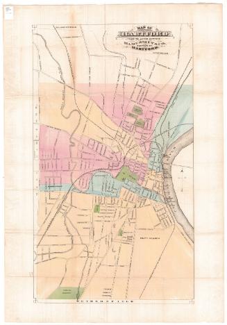
Map of the City of Hartford, Connecticut
SurveyorSurveyed by
E. C. Smith
(American)
SurveyorSurveyed by
H. E. Van Zandt
(American)
PrintmakerLithographed by
William H. Rease
(American, 1818 - after 1860)
PrinterPrinted by
William H. Rease
(American, 1818 - after 1860)
PublisherPublished by
Eneas Smith
(American)
Date1859
MediumLithography; black printer's ink and watercolor on paper
DimensionsPrimary Dimensions (image height x width): 56 x 53 1/2in. (142.2 x 135.9cm)
Sheet (height x width): 58 x 54 3/8in. (147.3 x 138.1cm)
Sheet (height x width): 58 x 54 3/8in. (147.3 x 138.1cm)
ClassificationsGraphics
Credit LineConnecticut Museum of Culture and History collection
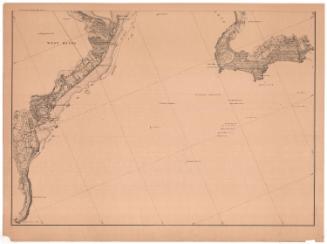
DescriptionStreet map of Hartford, Connecticut, extending from Spring Grove Cemetery to the north, to the Connecticut River to the east, to Wawarme Avenue to the south, and Sigourney Street to the west. The city's wards are labeled on the map. Buildings and their lot numbers are given, with different types of shading for different uses. Notable landmarks include cemeteries; Bushnell and other parks; Trinity College; the Hartford and New Haven; Hartford, Providence and Fishkill; and the Hartford and Springfield Railroads and Union Station. In the top right corner, there is an inset map of Hartford in 1640, and just below it, a map of Hartford school districts. The map is framed with a decorative border of stylized leaves.
Object number2012.312.175
NotesCartographic Note: Scale: 1 inch equals 250 feetOn View
Not on view