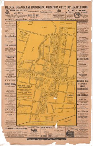
Rippey's Business Map of Hartford, Connecticut
PublisherPublished by
Joseph Rippey
(American)
Date1886
MediumLithography; black and red printer's ink on paper
DimensionsPrimary Dimensions (image height x width): 44 1/2 x 34in. (113 x 86.4cm)
Sheet (height x width): 46 3/8 x 35 3/4in. (117.8 x 90.8cm)
ClassificationsGraphics
Credit LineConnecticut Museum of Culture and History collection
Object number2012.312.172
DescriptionStreet map of Hartford, Connecticut, oriented east-west with the Connecticut River at the bottom of the map. It extends from Willow Street at the top, Pine Street to the right, the Connecticut River at the bottom, and Jefferson Street to the left. The Park River runs north-south through the center of the map. Notable landmarks include the New York, New Haven and Hartford Railroad line, Union Station and the round house; Bushnell Park and the state capitol building; Zion Hill Cemetery; St. Joseph's Cathedral and seminary; and Hartford High School. Below the map there is a directory of local businesses, the locations of which are marked on the map in red. Above the map and to the left of the directory are advertisements, some with images of the business. In the lower right corner of the map, there is a copyright statement.
Label TextRippey's Business Map provides a vivid glimpse of bustling late Victorian Hartford. Overall, the map has a surprisingly modern look, with advertisements surrounding a large street map of downtown Hartford. Display ads showcase not only Travelers Insurance Company and the major hotels, the Allyn House ("Strictly First-Class, with all modern conveniences") and the United States Hotel; but also French's Hack and Livery Stable; M. A. Quinn, Horse Shoer ("Particular attention given to the shoeing of Gentlemen's Driving and Coach Horses"), and the Hartford Model Bowling Alley and Pool Room. A directory lists additional businesses, including two clairvoyants (Miss A. E. Colt and Mrs. M. A. Greenleaf), a billiard parlor, eight restaurants, twenty-three saloons, and eleven wine and liquor stores. All of these varied businesses would have paid to have their names and locations featured on the map, apparently in the hope that they would appeal to business travelers. Although the map has a distinctly local feel, Joseph Rippey, who produced the map, was not a local businessman himself. Based in New York City, he produced similar maps of many other cities.
NotesCartographic Note: No scaleStatus
Not on view