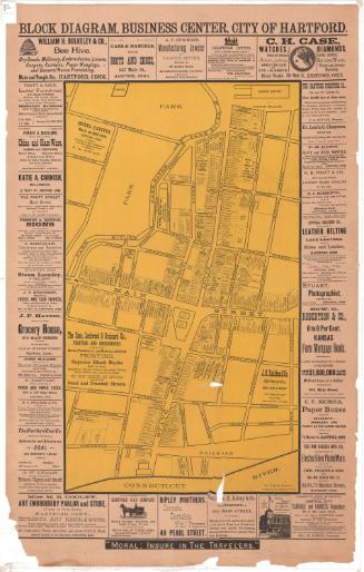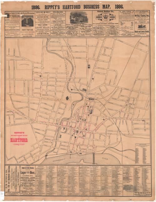
Rippey's Business Map of Hartford, Connecticut
PublisherPublished by
Joseph Rippey
(American)
Date1886
MediumLithography; black and red printer's ink on paper
DimensionsPrimary Dimensions (image height x width): 44 1/2 x 34in. (113 x 86.4cm)
Sheet (height x width): 46 3/8 x 35 3/4in. (117.8 x 90.8cm)
Sheet (height x width): 46 3/8 x 35 3/4in. (117.8 x 90.8cm)
ClassificationsGraphics
Credit LineConnecticut Museum of Culture and History collection
DescriptionStreet map of Hartford, Connecticut, oriented east-west with the Connecticut River at the bottom of the map. It extends from Willow Street at the top, Pine Street to the right, the Connecticut River at the bottom, and Jefferson Street to the left. The Park River runs north-south through the center of the map. Notable landmarks include the New York, New Haven and Hartford Railroad line, Union Station and the round house; Bushnell Park and the state capitol building; Zion Hill Cemetery; St. Joseph's Cathedral and seminary; and Hartford High School. Below the map there is a directory of local businesses, the locations of which are marked on the map in red. Above the map and to the left of the directory are advertisements, some with images of the business. In the lower right corner of the map, there is a copyright statement.
Object number2012.312.172
NotesCartographic Note: No scaleOn View
Not on view