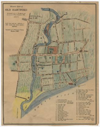
Dutch Land in Hartford, Connecticut
MakerMade by
Albert L. Washburn
(American, 1857 - 1948)
Date1904
MediumDrawing; black ink and pastel on wove paper, lined with linen
DimensionsPrimary Dimensions (image height x width): 20 7/8 x 28 3/4in. (53 x 73cm)
Sheet (height x width): 22 1/8 x 30in. (56.2 x 76.2cm)
Mount (height x width): 22 1/8 x 30in. (56.2 x 76.2cm)
ClassificationsGraphics
Credit LineConnecticut Museum of Culture and History collection
Object number2012.312.170
DescriptionMap of Dutch land in Hartford, Connecticut, in the 1660s, extending from the Little or Mill River to the north, the Vresch (Connecticut) River to the east, the highway to South Meadow to the south, and Taylor street to the west. The plots of land shown on the map are labeled with the owner's name or the owner and previous owner's names. Outlined in green are the Dutch land areas.
Label TextThe civil engineer Albert L. Washburn was known as an outstanding title searcher. According to his obituary in the Hartford Courant, about 1903, working for the Hartford Electric Light Company, he traced the ownership of the South Meadow property where the light company was erecting a new plant "as far back as the Indians." It may have been at that time that he compiled this map of Dutch Land in Hartford. Washburn was considered a national authority on the history of Hartford and its landmarks and published several books on the subject. He also owned a remarkable collection of old maps. Washburn's map of Dutch Land is a good example of the ongoing interest of Hartford's citizens in the early history of their city. This interest is reflected in other maps from around 1900.
NotesCartographic Note: No scaleStatus
Not on view


Silvermine Production
1973