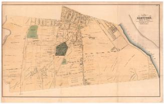
Charter Oak Place, showing property of Julius Gilman and others
SurveyorSurveyed by
Seth E. Marsh
(American, about 1823 - 1878)
Date1860
MediumDrawing; black ink and pencil on wove paper, lined with linen
DimensionsPrimary Dimensions (image height x width): 24 7/8 x 39in. (63.2 x 99.1cm)
Sheet (height x width): 24 7/8 x 41 5/8in. (63.2 x 105.7cm)
Mount (height x width): 24 7/8 x 41 5/8in. (63.2 x 105.7cm)
ClassificationsGraphics
Credit LineConnecticut Museum of Culture and History collection
Object number2012.312.169
DescriptionMap of Governor Street, Charter Oak Place and Charter Oak Avenue in Hartford, Connecticut. Lots of land are depicted, with measurements in feet, showing the location and general shape of the buildings on them. Landowners include Julius Gilman, Robinson Bissell & Company, H. Kellogg, F.W. Cady, Nelson Kingsbury, and Nathaniel Shipman.
Label TextThe venerable Charter Oak, where the Connecticut Charter was concealed during the 1600s, fell in a storm on the night of August 20, 1856, and within a few years, the property on Charter Oak Hill was being developed as a fashionable new residential district. Charter Oak Avenue was laid out over the hill, and stately home were erected along it by many of Hartford's most prominent citizens. Julius Gilman was one of the original residents of the area. In the early 1860s, his original farmhouse, shown on this map, was replaced by a new mansion in the popular second Empire style.
NotesCartographic Note: Scale: 1 inch equals 32 feetStatus
Not on view

ca. 1850-1870