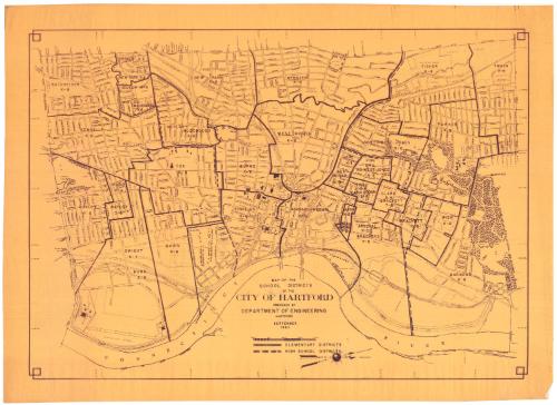
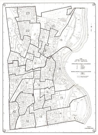
Map of the School Districts of the City of Hartford
DraftsmanDrawn by the
Engineering Department (Hartford, Conn.)
(American, founded 1907)
Date1965
MediumPhotostat; gelatin silver print on paper
DimensionsPrimary Dimensions (image height x width): 22 3/4 x 32in. (57.8 x 81.3cm)
Sheet (height x width): 25 5/8 x 35 1/4in. (65.1 x 89.5cm)
ClassificationsGraphics
Credit LineConnecticut Museum of Culture and History collection
Object number2012.312.168
DescriptionMap of the school districts in Hartford, Connecticut, oriented so that north points to the right side of the sheet and the Connecticut River appears on the bottom. Solid and broken lines indicate elementary school districts and high school districts, respectively.
Label TextBetween 1950 and 1960, 60,000 people--about half the population--moved out of the city of Hartford. During the same period, 68,000 people moved into the city. The newcomers were primarily low-income, non-white, and non-English-speaking, and their arrival produced great economic and racial imbalance in the Hartford school system. A 1965 study of Hartford's schools by the Center for Field Studies of the Harvard School of Education recommended the creation of new schools and the provision of transportation--busing--as the solution to this problem. This 1965 map reflects the status quo at the time of this study.
NotesCartographic Note: Scale: 1 inch equals 1000 feetStatus
Not on view
Kellogg & Bulkeley
1915-1920

Kellogg & Bulkeley
1910-1915