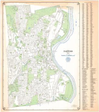
City of Hartford, Connecticut
MakerMade by
Metropolitan District Commission
(American, founded 1929)
Date1973
MediumScreen print; black, blue and turquoise printer's inks on wove paper
DimensionsPrimary Dimensions (image height x width): 32 1/8 x 23 1/8in. (81.6 x 58.7cm)
Sheet (height x width): 33 1/8 x 29 1/8in. (84.1 x 74cm)
ClassificationsGraphics
Credit LineConnecticut Museum of Culture and History collection
Object number2012.312.167
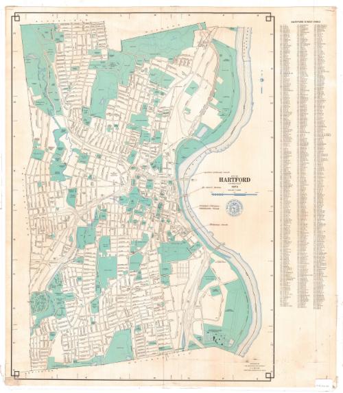
DescriptionMap of Hartford, Connecticut, from the town lines of Bloomfield and Windsor to the north, the Connecticut River to the east, the town lines of Newington and Wethersfield to the south, and the town line of West Hartford to the west. Streets are labeled and public spaces, including parks, schools, colleges, municipal infrastructure and cemeteries are colored turquoise. Water sources (rivers, reservoirs, ponds and the like) are denoted with blue lines. To the right of the map is the street index.
Label TextAt first glance this map appears to be a standard street map of Hartford and certainly it would have served that purpose admirably. However, the Metropolitan District Commission, who prepared this map for the City of Hartford, was primarily responsible for the city's water supply, and prominently featured on the map is a new Water Pollution Control Plant, located just south of Brainard Airport. Planning for the massive plant began in 1961 and it was finally completed and dedicated in November 1972. In addition to serving as a street map and celebrating the completion of Hartford's new sewage treatment plant, the map was also used by an unknown person for an unknown purpose either in 1973 or at some later date. Someone has penciled in the names and locations of three historic houses and St. John's Church, all in downtown Hartford.
NotesCartographic Note: Scale: 1 inch equals 1000 feetStatus
Not on view