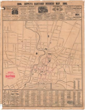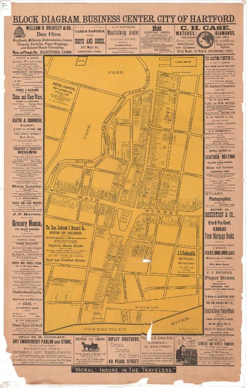
Block Diagram, Business Diagram, City of Hartford
DraftsmanDrawn by
Harry R. Williams
(American, 1861 - 1956)
PrinterPrinted by
Case, Lockwood and Brainard Company
(American)
Dateabout 1896
MediumLithograph; black and yellow printer's inks on wove paper
DimensionsPrimary Dimensions (image height x width): 28 1/4 x 16 1/4in. (71.8 x 41.3cm)
Sheet (height x width): 38 3/8 x 24in. (97.5 x 61cm)
ClassificationsGraphics
Credit LineConnecticut Museum of Culture and History collection
Object number2012.312.165
DescriptionStreet map of downtown Hartford, Connecticut, from Union Depot to the north, Church and Morgan Streets to the east, the Connecticut River to the south, and the Park River to the west. The map shows lots containing street numbers and the names of businesses and/or business owners. Several advertisements appear on the map itself: Hotel Capitol, The Case, Lockwood & Brainard Company, and J.G. Rathbun & Company. Around the map on all sides are advertisements for the businesses, some consisting only of the name and address and a brief description, and some with a pictorial depiction of some aspect of the business.
Label TextMany small shops line the streets of Hartford's business district in this 1890s map. The Bee-Hive, at the corner of Main and State Streets, is the largest department; both Fox's and Brown Thompson's, which would dominate the retail trade in the early twentieth century, are still in their infancy, occupying tiny stores farther down the block. The Hartford Cab Company on State Street advertised hacks, coupes, victorias, and light livery to let; Miss M. E. Cooley invited visitors to examine specimens of art needlework at her art embroidery parlor and store on Pratt Street. The format, with eye-catching advertisements surrounding a central map, continues to be used in the twenty-first century, primarily for tourist maps.
NotesCartographic Note: No scaleThe map contains no dates, or publisher but, note that one business, 'Capitol City Carriage and Harness Repository' opened in 1985. Therefore the map was made then or soon after.
Status
Not on view