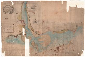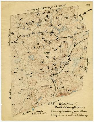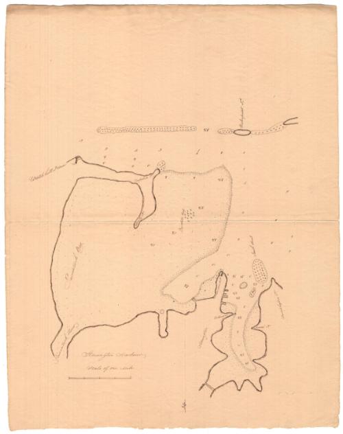
Stonington Harbor
SurveyorSurveyed by
Unknown
Datebefore 1824
MediumDrawing; ink on paper
DimensionsPrimary Dimensions (image height x width): 17 x 14 1/2in. (43.2 x 36.8cm)
Sheet (height x width): 22 x 17 3/8in. (55.9 x 44.1cm)
ClassificationsGraphics
Credit LineMuseum purchase
Object number1975.102.2
DescriptionManuscript map of Stonington Harbor, Connecticut, from Stonington to the north, Pawcatuck Bay to the east, Wickapuset Island to the south, and Wamphassoc Point to the west. The mouth of the Pawcatuck River is in the top right corner. Water depth is given (presumably in meters), and the locations of shoals and reefs are marked with Xs and labeled. The title appears upside down when viewing the map with the north arrow, located at the top, pointing up.
Label TextThis hand-drawn chart of Stonington Harbor must date from before 1824, the date when the lighthouse was erected on Stonington Point. The chart shows a windmill on the point, which is labelled "Windmill Point," but the only lighthouse that appears is the Watch Hill Lighthouse across the harbor in Rhode Island. With few aids to navigation, negotiating the shallow waters around Stonington must have presented a challenge to local sailing captains, one of whom presumably prepared this chart.
NotesCartographic Note: Scale: Almost 3 1/4 inches equals 1 mileStatus
Not on view