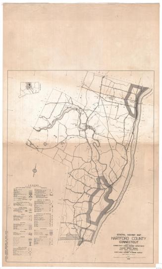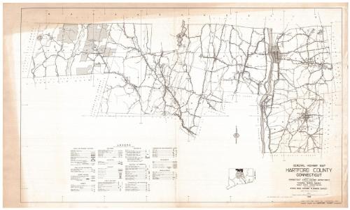
General Highway Map, Hartford County, Connecticut
PublisherPublished by
Connecticut State Highway Department
(American, 1895 - 1969)
PublisherPublished by
Federal Works Agency
(American, 1939 - 1949)
Date1938
MediumLithography; black printer's ink on wove paper
DimensionsPrimary Dimensions (image height x width): 17 5/8 x 28 7/8in. (44.8 x 73.3cm)
Sheet (height x width): 18 5/8 x 31in. (47.3 x 78.7cm)
ClassificationsGraphics
Credit LineConnecticut Museum of Culture and History collection
Object number2012.312.155
DescriptionMap of Hartland, Granby, East Granby, Suffield, Enfield and East Windsor, Connecticut, in Hartford County, from the state line of Massachusetts to the north; the Tolland county line to the east; the Litchfield county line and Canton, Simsbury, Bloomfield, Windsor, Windsor Locks and South Windsor town lines to the south; and the Litchfield county line to the west. Landmarks include Tunxis State Forest and Old Newgate Prison. Highways and roads of various surfaces are prominently featured, with bridges; airways; railroads; drainage systems (streams, rivers, marshes, reservoirs, lakes, etc.); public, private and industrial buildings; and conservation and recreation areas also depicted. The symbols and lines used to denote these features are explained on the legend, located below the map.
Label TextA wealth of information is included on this map showing northern Hartford County in 1938. The towns of Hartland, Granby, East Granby, Suffield, and Enfield are still largely rural, characterized by farms and forests. Urban areas are shown in Thompsonville, where the carpet factory remained in operation despite being hit hard by the Great Depression, and Broad Brook, where the local mill continued turning out fabric for automobile upholstery, despite rumors of the plant closing. Oddly, the location of the Enfield Shaker Village is indicated, though the Shakers had sold the property to the State of Connecticut in 1915, and abandonned the site shortly thereafter.
NotesCartographic Note: Scale: 1 inch equals 1 mileStatus
Not on view