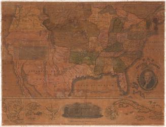
Map of the United States
PrinterPrinted by
Case,Tiffany & Co.
(1836 - 1857)
PublisherPublished by
Case,Tiffany & Co.
(1836 - 1857)
Date1851
MediumLithography; black printer's ink and watercolor on wove paper
DimensionsPrimary Dimensions (image height x width): 22 3/4 x 24 5/8in. (57.8 x 62.5cm)
Sheet (height x width): 23 3/4 x 25 5/8in. (60.3 x 65.1cm)
ClassificationsGraphics
Credit LineConnecticut Museum of Culture and History collection
Object number2012.312.154
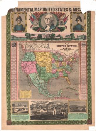
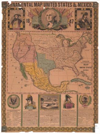
DescriptionMap of the United States, Mexico, Central America, Cuba, Jamaica and Haiti, from the border of Canada to the north, the Atlantic Ocean to the east, Panama to the south, and the Pacific Ocean to the west. The states and countries are colored green, blue, pink or yellow and are further defined by border lines. To the right of the map is an explanation of the symbols marking capital cities, "important" towns, large towns, smaller towns, missionary stations, court houses, forts, canals, military posts and mines. Elevation is depicted by the use of hachure marks. Two routes are marked, that from New York to Chagres, and that from Panama to San Francisco. The cartouche contains a portrait of George Washington below an eagle holding an olive branch, arrows and a seal featuring the flag of the United States. Below the portrait of Washington are two oak branches laden with acorns. In the Gulf of Mexico area of the map is a vignette of the United States Capitol.
Label TextThe Treaty of Guadelupe Hildago ended the war between the United States and Mexico on Februrary 2, 1848. The first edition of this map printed and published in Hartford, Connecticut by Case, Tiffany & Co. was intended to show the boundaries of the two countries as established by the treaty negotiations. However, both the first edition of the map and also subsequent editions contained many inaccuracies, showing territorial boundaries in unusual and unexpected and sometimes outdated configurations. This peculiarity is further enhanced by the unusual conic projection, which causes the southern portion of the map, including Mexico, to appear unnaturally large. Projecting the shapes of the geographical features of a three-dimensional, nearly round globe onto a two-dimensional, flat piece of paper always presented mapmakers with a challenge and always distorts their actual appearance to some extent. The Hartford printer Case, Tiffany & Co. produced many maps during the 1840s and 1850s, many of them for use in schools.
NotesCartographic Note: Scale: 2 1/2 inches equals 300 milesStatus
Not on view