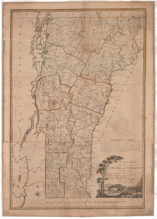
A Correct Map of the State of Vermont From actual Survey
MakerCompiled by
James Whitelaw
(American, 1748 - 1829)
PrinterEngraved by
Amos Doolittle
(American, 1754 - 1832)
PrinterPrinted by
Amos Doolittle
(American, 1754 - 1832)
Date1796
MediumEngraving; printer's ink and watercolor on paper
DimensionsPrimary Dimensions (image height x width): 45 1/4 x 30 1/2in. (114.9 x 77.5cm)
Sheet (height x width): 48 3/8 x 34 1/4in. (122.9 x 87cm)
ClassificationsGraphics
Credit LineConnecticut Museum of Culture and History collection
Object number2012.312.153
DescriptionMap of Vermont, bordered on the north by Canada, the east by New Hampshire, the south by Massachusetts and the west by New York. Lines of latitude and longitude, the latter in degrees east from Washington, are marked in the border. The counties are outlined in double solid lines that have been hand colored in red, yellow, or green. Townships are outlined in single solid lines and include their dates of charter. Contested lines are marked as broken solid lines. On the right side is a key to the symbols found on the map: public roads, meeting houses, forts, falls, ferries, bridges, grist mills, saw mills, fulling mills, iron works, mountains, swamps, dwelling houses and grammar schools. An eight-point compass rose appears in the lower left.
The cartouche, in the lower right corner, is unframed and features a pastoral scene. Two trees on the left arch over the title text. Below the text is the depiction of farming life: a man and a woman walk behind a horse-drawn hay wagon with two people riding on the hay. In the foreground, two sheep sit in a small clearing surrounded by tree stumps, and to the right, two cows stand in a small running brook. A farmhouse and silo are behind a small orchard, and two fields with wheat sheaves are visible in the background.
The cartouche, in the lower right corner, is unframed and features a pastoral scene. Two trees on the left arch over the title text. Below the text is the depiction of farming life: a man and a woman walk behind a horse-drawn hay wagon with two people riding on the hay. In the foreground, two sheep sit in a small clearing surrounded by tree stumps, and to the right, two cows stand in a small running brook. A farmhouse and silo are behind a small orchard, and two fields with wheat sheaves are visible in the background.
Label TextFollowing the American Revolution, the individual states set out to create maps accurately showing their boundaries, geographical features, roads, towns, and public lands for sale. In Vermont, each town was required to conduct a survey and submit the results to Surveyor General James Whitelaw for compilation into a single comprehensive map. The map was engraved by the New Haven, Connecticut artist Amos Doolittle, presumably because there was no engraver of adequate skill in Vermont. This large scale detailed map set a high standard and served as a model for other state maps issued in subsequent years. These maps often took a very long time to produce, because it was difficult to obtain surveys for all of the individual towns. Some Vermont towns had not submitted their surveys by the time this map was engraved, resulting in gaps in some areas.
NotesCartographic Note: 5 1/4 inches equals 20 milesStatus
Not on view


Joel Knott Allen
1791 or 1792