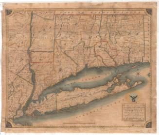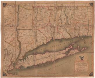
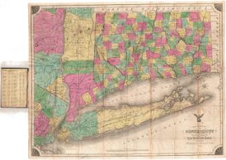
The State of Connecticut Including Parts of New York and New Jersey
PrinterPrinted by
Roderick Nevers
(American, 1808 - 1888)
Date1851
MediumEngraving; black printer's ink and watercolor on paper, lined with linen
DimensionsPrimary Dimensions (image height x width): 23 1/4 x 28 3/8in. (59.1 x 72.1cm)
Sheet (height x width): 27 1/2 x 31 3/4in. (69.9 x 80.6cm)
Mount (height x width): 27 1/2 x 31 3/4in. (69.9 x 80.6cm)
Sheet (height x width): 27 1/2 x 31 3/4in. (69.9 x 80.6cm)
Mount (height x width): 27 1/2 x 31 3/4in. (69.9 x 80.6cm)
ClassificationsGraphics
Credit LineMuseum purchase
DescriptionMap of Connecticut with parts of New York State and New Jersey, from the border of Massachusetts to the north; the border of Rhode Island to the east; the Atlantic Ocean to the south; and Orange County, New York, to the west. The state borders between Connecticut, New York and New Jersey are outlined in red, and the states are divided into counties and towns. Physical features include rivers; mountains, depicted with clusters of peaks; lakes; and islands. Several railroad lines are displayed, including the Long Island; New York and New Haven; Housatonic; Naugatuck; New Haven, Hartford and Springfield; Canal; New Haven and New London; Norwich and Worcester; New York and Erie; and Harlem Railroads. Several proposed railroad lines are depicted, as well. Above the title, in the lower right corner, is the depiction of an eagle, wings outstretched, perched atop a globe and surrounded by stars.
Object number1982.133.0
NotesCartographic Note: Scale: 1 inch equals 5 milesOn View
Not on view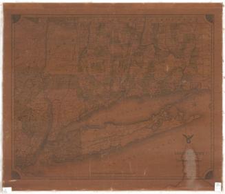

Lucius Stebbins & Co.
1859