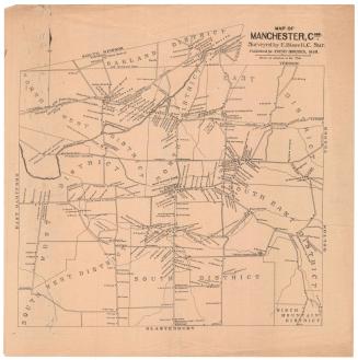
A Correct Map of the Underground Excavation at the Phoenix Mine
SurveyorSurveyed by
Amasa Holcomb
(American, 1787 - 1873)
Date1831
MediumDrawing; black ink and water color on paper, lined with paper
DimensionsPrimary Dimensions (image height x width): 22 5/8 x 27 3/4in. (57.5 x 70.5cm)
Sheet (height x width): 23 x 28 1/4in. (58.4 x 71.8cm)
Mount (height x width): 23 x 28 1/4in. (58.4 x 71.8cm)
ClassificationsGraphics
Credit LineGift of C. Russell Noyes
Object number1952.97.1
DescriptionMap of the Phoenix Copper Mine in Granby, Connecticut, showing the mine from above. The letters B-F, H, L and M appear on the map, though there is no indication of what they represent. Several parts of the mine are labeled, including the north and south sounding rooms, the mouth of the old shaft, an unexplored part of the old shaft, a pillar, and the foot of a ladder on the west side of the mine.
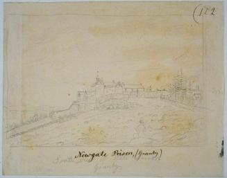
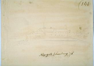
Label TextAmasa Holcomb (1787-1873) was a civil engineer and surveyor who also made and sold surveying instruments, including chains, compasses, and small transit telescopes. While he may not be the individual responsible for this map--there were at least two other men named Amasa Holcomb living in the Granby area--the challenge of surveying the underground chambers of the former Newgate Prison, seems likely to have appealed to someone of Holcomb's talents. Copper had been successfully mined at the site during the 1700s, and the Phoenix Mine Company hoped to revive these operations in the 1830s, using up-to-date technology and steam engines. This produced the need for an accurate survey. The British mining engineer Westgarth Forster had surveyed the hillside where the mine is located in 1830, but his map gives only a rough idea of the location of the underground works. Holcomb's map is much more detailed, showing the maze of tunnels that lay beneath the surface.
NotesCartographic note: Scale: 1 inch equals 12 1/2 feetStatus
Not on view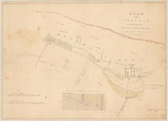

ca. 1950

Charles T. Stuart
1892-1902