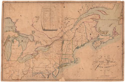
Map of the Seat of War in North America
DraftsmanDrawn by
John Melish
(Scottish, 1771 - 1822)
PrintmakerEngraved by
Henry Schenck Tanner
(American, 1786 - 1858)
DateProbably 1813
MediumEngraving; black printer's ink and watercolor on wove paper
DimensionsPrimary Dimensions (image height x width): 14 1/2 x 22 1/8in. (36.8 x 56.2cm)
Sheet (height x width): 14 3/4 x 22 5/8in. (37.5 x 57.5cm)
Sheet (height x width): 14 3/4 x 22 5/8in. (37.5 x 57.5cm)
ClassificationsGraphics
Credit LineGift of Sherman W. Adams
DescriptionMap of the northern United States and Canada from the Ohio River and Washington, D.C. in the south to the area north of Lake Superior, the Saint Laurence River, and the Straits of Belisle in the north and from Lake Michigan and the Indiana Territory in the west to western Newfoundland and Sable Island in the east. State boundaries, major cities, and some geographical features are identified. Major roads within the United States and Upper Canada are shown. A scroll with a Table of Population for the United States (7,239,993), the British Possessions (339,000), and some individual states, provinces, and cities is at upper center.
Object number1893.15.3
NotesCartographic Note: 1 1/2 inches = 100 miles
Date Note: This state of the map does not exactly correspond to the impression in the David Rumsey collection from the November 1813 edition of Melish's Military and Topographical Atlas of the United States. The map in the Rumsey collection includes James Bay and extends the boundary between Upper and Lower Canada to the north. The signature reads "H. S. Tanner Dirext." rather than "H.S. Tanner Sc." as on this map. These differences suggest that the map in the Connecticut Historical Society collection may be an earlier state.
Dimensions Note: The size of the plate is not indicated because the map has been trimmed within the platemark.
On View
Not on view