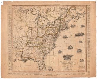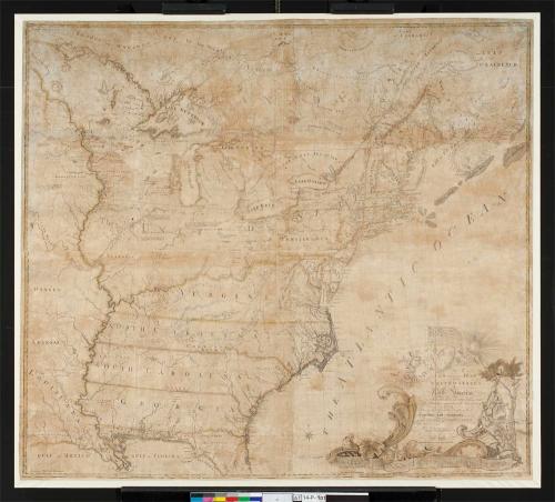

A New and Correct Map of the United States of North America
PrinterEngraved by
Abel Buell
(American, 1742 - 1784)
PrinterPrinted by
Abel Buell
(American, 1742 - 1784)
PublisherPublished by
Abel Buell
(American, 1742 - 1784)
Date1784
MediumEngraving; printer's ink on laid paper
DimensionsSheet (height x width): 43 1/4 × 48 3/4in. (109.9 × 123.8cm)
Frame (height x width x depth): 45 3/4 × 50 3/4 × 2 3/4in. (116.2 × 128.9 × 7cm)
ClassificationsGraphics
Credit LineConnecticut Museum of Culture and History collection
Object number1950.553.0
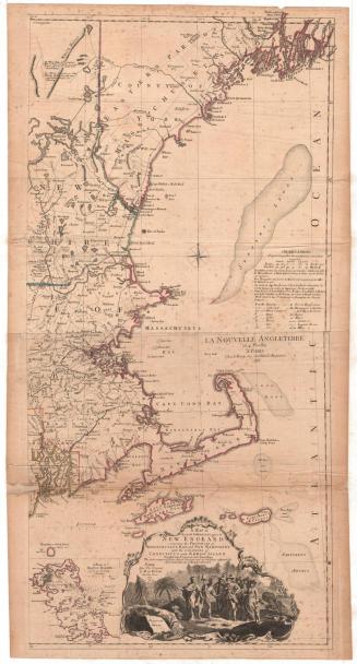
DescriptionGeopolitical map of the United States following the Revolutionary War, in two separate pieces, (.a) and (.b). It shows new boundaries as determined at the Treaty of Paris: to the north is Canada's James Bay; to the east, the Gulf of St. Lawrence and the Atlantic Ocean; to the south, the Gulf of Mexico and what was then known as the Gulf of Florida; to the west, lands beyond the Mississippi River. Canadian places named on the map include Quebec, Nova Scotia, Labrador, and the boundary of Hudson Bay. The American states named on the map are Massachusetts, Hampshire, Vermont, Rhode Island, Connecticut, New York, New Jersey, Pennsylvania, Delaware, Maryland, Virginia, North Carolina, South Carolina and Georgia. Maine, Arkansas, Louisiana and Florida also appear on the map, but were not states at the time.
The cartouche appears in the lower right corner of (.b). On the left of the cartouche, a winged figure blowing a horn heralds the American flag, lit by the rising sun. The figure represents Minerva, the Roman goddess of wisdom, commerce, and war. On the flag are thirteen stars, arranged in five rows, and thirteen stripes. A winged cherub holds up a fringed, oval item (a piece of fabric, possibly). On it is the Connecticut State Seal with three grapevines. To the right of the title, a female figure representing Liberty sits under a tree, holding a liberty cap on a pole in her right hand. In her left, she holds a globe inscribed "America." At her feet is a scroll inscribed with the first Independence Day.
The cartouche appears in the lower right corner of (.b). On the left of the cartouche, a winged figure blowing a horn heralds the American flag, lit by the rising sun. The figure represents Minerva, the Roman goddess of wisdom, commerce, and war. On the flag are thirteen stars, arranged in five rows, and thirteen stripes. A winged cherub holds up a fringed, oval item (a piece of fabric, possibly). On it is the Connecticut State Seal with three grapevines. To the right of the title, a female figure representing Liberty sits under a tree, holding a liberty cap on a pole in her right hand. In her left, she holds a globe inscribed "America." At her feet is a scroll inscribed with the first Independence Day.
Label TextThe New Haven silversmith Abel Buell engraved, printed, and published the first map of the United States less than a year after the Treaty of Paris which ended the Revolutionary War. His map includes one of the first representations of the flag of the new republic together with a prominent representation of the Connecticut State Seal. Buell was not a cartographer; he based his map on pre-existing sources, primarily the map of North America by John Mitchell, which was used in negotiating the Treaty. Following the Colonial charter, he showed Connecticut’s western boundary extending beyond the Mississippi River, taking in huge portions of Pennsylvania, Ohio, Indiana, and Illinois along the way. The name “Connecticut” proudly appears immediately beneath the name of the United States, near a description of “Extensive Natural Meadows….where…. large herds of BUFFALO and other Beasts resort for Grass and Salt.” Connecticut's western land claims were a source of much contention. In 1784, when Buell's map was published, armed conflict was taking place in the Wyoming Valley between settlers from Connecticut and those from Pennsylvania.
NotesCartographic Note: Scale: 60 1/2 English miles to a DegreeStatus
Not on view