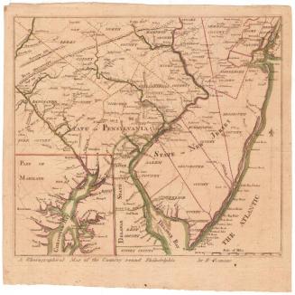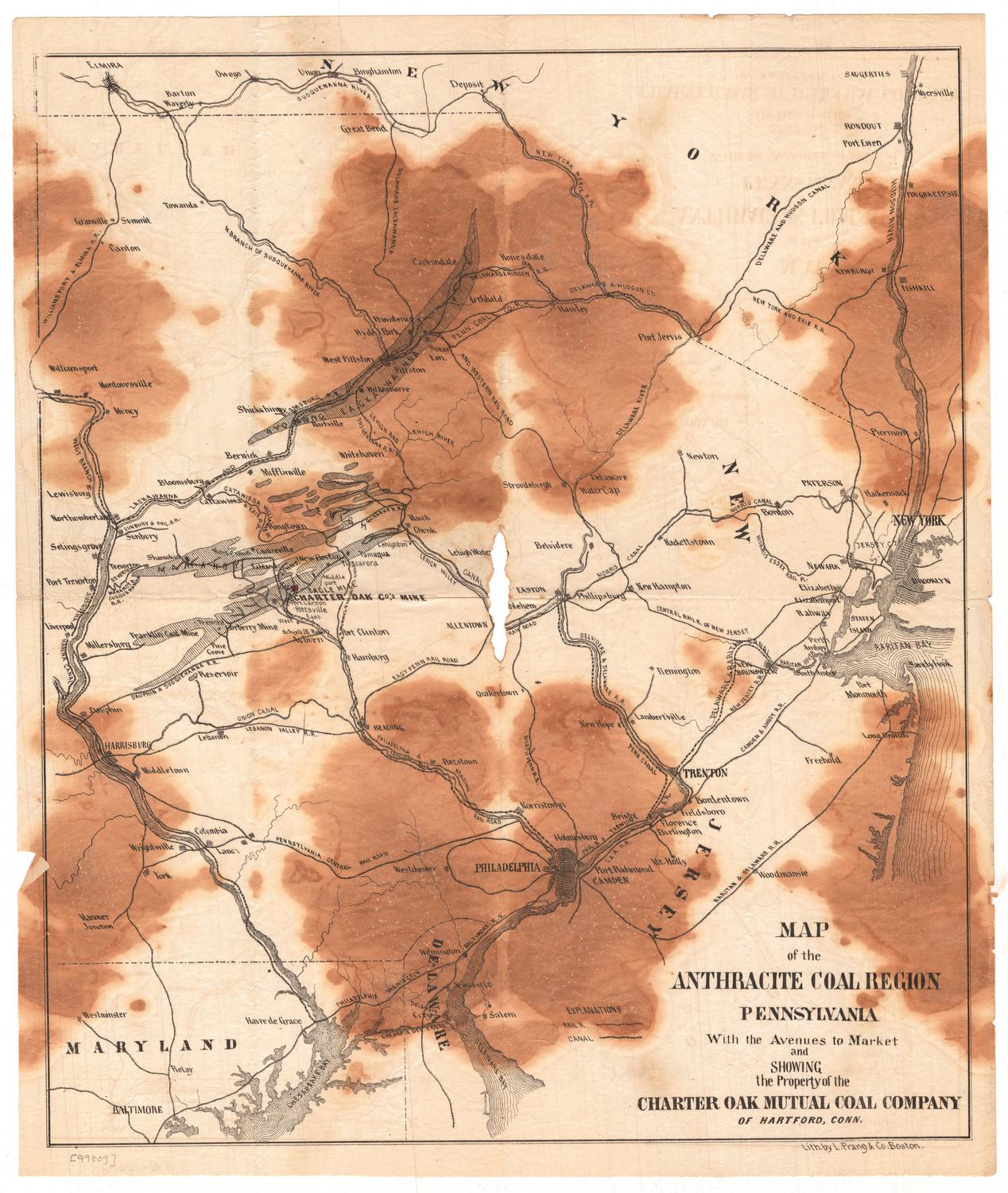
Map of the Anthracite Coal Region, Pennsylvania
PrinterPrinted by
L. Prang & Co.
(American, 1861 - 1899)
PublisherProbably published by
Charter Oak Mutual Coal Company
(American, 1865 - 1866)
Date1865
MediumLithography; black pritner's ink on wove paper
DimensionsPrimary Dimensions (image height x width): 15 7/8 x 13 1/2in. (40.3 x 34.3cm)
Sheet (height x width): 16 7/8 x 14 1/4in. (42.9 x 36.2cm)
ClassificationsGraphics
Credit LineConnecticut Museum of Culture and History collection
Object number2005.183.0
DescriptionMap of northeastern Pennsylvania's coal region, from the border of New York to the north, New Jersey to the east, Delaware to the south, and the Susquehanna Canal to the west. Local coal mines are shown, particularly the location of the Charter Oak Mutual Company's mine, which is marked with a red box. The Sunbury and Philadelphia; Dauphin and Susquehanna; Philadelphia and Reading; Philadelphia, Wilmington and Baltimore; East Pennsylvania; North Pennsylvania; Belvidere and Delaware; Philadelphia and Trenton; Raritan and Delaware; Camden and Amboy; Centrail Roalroad of New Jersey; Delaware, Lackawanna and Western; and the New York and Erie Railroads are all shown. The Susquehanna River and Canal, the Chesapeake and Raritan Bays and the Delaware Bay and River are shown, as well.
Label TextAnthracite coal was critical to production of iron rails, which the rapidly expanding railroads required in vast quanities in the mid-1800s. The Charter Oak Mutual Coal Company was established in Hartford in 1865 with the stated purpose of mining anthracite coal in Pennsylvania. The originators of the company were Paul P. Todd of Boston and John H. Bracken of Pennsylvania. The name "Charter Oak," recalling the venerable tree in which Connecticut's Colonial Charter was hidden and preserved, was probably meant to inspire investors with confidence. Articles describing the mines in glowing terms appeared in the Hartford Courant and this map was probably issued at the same time to familiarize investors with the mines' location. Much stock was sold, but the promised profits failed to materialize, and in 1866 Todd and Bracken were charged with fraud.
NotesCartographic Note: No scaleStatus
Not on view