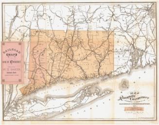
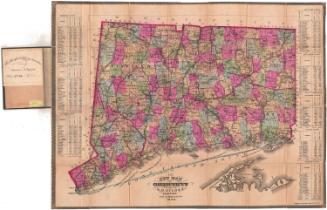
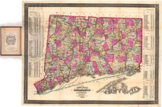
Map of the Railroads of Connecticut to accompany the report of the Railroad Commissioners
MakerPrepared by
Samuel D. Tilden
(American, 1828 - 1893)
PrintmakerLithographed by
Bingham & Dodd
(1860 - 1878)
Date1878
MediumLithography; black and orange printer's inks on paper
DimensionsPrimary Dimensions (image height x width): 21 x 27in. (53.3 x 68.6cm)
Sheet (height x width): 22 3/4 x 28 1/4in. (57.8 x 71.8cm)
ClassificationsGraphics
Credit LineConnecticut Museum of Culture and History collection
Object number2012.312.146
DescriptionMap of Connecticut, from Massachusetts to the north, Rhode Island to the east, Long Island and the Long Island Sound to the south, and New York to the west. It shows the railroad lines in the state: New York, New Haven and Hartford; Danbury and Norwalk; Housatonic; New Haven and Northampton; Boston and New York Air Line; Naugatuck; Connecticut Western; Connecticut Central; Connecticut Valley; New London Northern; Norwich and Worcester; New York and New England; and New York, Providence and Boston Railroads. Most of the railroads are denoted with solid black lines, but some have broken solid lines, which may indicate lines not yet built. The railroads in the surrounding states are also labeled.
Label TextThe year 1878 was marred by one of the worst train wrecks in Connecticut history. On 15 January 1878, a wooden truss bridge spanning the Farmington River at Tarfiffville collapsed beneath a train hurling its twin engines, a baggage car, and three passenger cars into the river gorge.Thirteen people were killed and many more were injured. The State Railroad Commissioners called for a thorough investigation of the causes of the accident and a special committee was created to inquire into the condition of other railroad bridges in the state. This map formed part of the Railroad Commissioners' regular report to the State Legislature, and was probably printed before the accident took place. It clearly shows the Western Railroad crossing the Farmington River at Tariffville, with no indication of the disaster which would soon take place at that site.
NotesCartographic Note: Scale: 1/2 inch equals 3 milesStatus
Not on view