
Map of New England
PrinterPrinted by
Ensign & Thayer
(American, 1849 - 1850)
After a work byAfter a work by
Lossing-Barritt
(American, 1846 - 1869)
PublisherPublished by
Ensign & Thayer
(American, 1849 - 1850)
PublisherPublished by
Joseph Ward
(American)
Date1847
MediumLithography; black ink and watercolor on wove paper
DimensionsPrimary Dimensions (image height x width): 28 1/8 x 22 3/8in. (71.4 x 56.8cm)
Sheet (height x width): 31 7/8 x 23 5/8in. (81 x 60cm)
ClassificationsGraphics
Credit LineConnecticut Museum of Culture and History collection
Object number2012.312.145
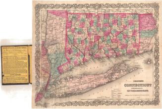
DescriptionMap of New England, from the border of Canada to the north and east, the Atlantic Ocean to the south, and New York State to the west. State and county borders are marked in broken solid lines, colored red; counties are also colored, either yellow, blue, green or pink. Cities are marked with circles and are labeled. Towns boundaries are not provided. Physical features include mountains, conveyed through hachure marks; rivers, lakes; and islands. Railroads are marked with crossed lines and are not labeled. Above the map to the left are six circles, one for each New England state, within which are the state seal on a square surrounded by other state symbology. At the top, the decorative border features the bald eagle with the American flag and shield and an olive branch, a ship at sea on the right and a town on the left. Other elements in the border include geometric patterns, the American shield, and scenes meant to evoke New England. The cartouche features a portrait of John Hancock, surrounded by a wreath; behind this is a depiction of the Boston Tea Party.
Label TextThe 1840s were a period of burgeoning industrialism, which saw immigrants from Europe flooding into the United States in ever-increasing numbers. Few signs of progress are evident in this 1847 map, however; it is decorated with images of farmers, agricultural products, Indians, the Boston Tea Party, and a portrait of John Hancock. A year later Ensign & Thayer printed a map of The United States & Mexico that appears to celebrate the progress of American industry as well as American victories in the war with Mexico. Perhaps these two viewpoints were not then seen as diametrically opposed as they appear today, or perhaps the two different maps were intended to target two different audiences. Ensign & Thayer were located in New York, but the Map of New England was published by Joseph Ward in Boston as well. The images of the Boston Tea Party and John Hancock would have appealed to potential purchasers in that city.
NotesCartographic Note: No scaleMedium Note: It seems likely that this map is a transfer lithograph, based on (or incorporating) wood-engravings by the firm Lossing-Barritt.
Status
Not on view


Object/Object