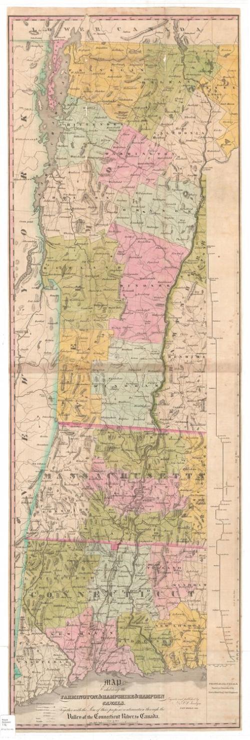
Map Exhibiting the Farmington & Hampshire & Hampden Canals, Together with the Line of their proposed continuation through the Valley of the Connecticut River, to Canada.
SurveyorSurveyed by
Davis Hurd
(American, 1788 - 1868)
PrintmakerEngraved by
N. & S. S. Jocelyn
(American, founded 1818)
PublisherPublished by
N. & S. S. Jocelyn
(American, founded 1818)
Date1828
MediumEngraving; black printer's ink and watercolor on wove paper
DimensionsPrimary Dimensions (image height x width): 48 1/4 x 15 5/8in. (122.6 x 39.7cm)
Sheet (height x width): 49 1/8 x 15 7/8in. (124.8 x 40.3cm)
Sheet (height x width): 49 1/8 x 15 7/8in. (124.8 x 40.3cm)
ClassificationsGraphics
Credit LineConnecticut Museum of Culture and History collection
DescriptionMap of the western New England states, from the Vermont-Canada border to the north, the border of New Hampshire to the east, the Long Island Sound to the south, and New York State to the west. The Farmington Canal and Hampshire and Hampden Canal are shown running through Connecticut and Massachusetts, with their proposed continuation through New Hampshire and Vermont to the border with Canada. To the right of the map there is an elevation profile of the canals. Other waterways, such as the Connecticut River, are shown, as are mountains, conveyed through hachure marks, and lakes. The states are divided into counties and towns, both delineated with lines that are defined in the Explanation list. Population centers are shown as clusters of small closed squares, and turnpikes and local roads are also depicted.
Object number2012.312.144
NotesCartographic Note: Scale: About 1/2 inches equals 3 milesOn View
Not on view