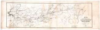
Map Exhibiting the Route of the Norwich & Worcester Railroad
SurveyorSurveyed by
James Pugh Kirkwood
(American, 1807 - 1877)
SurveyorSurveyed by
Homer T. Bostwick
(American)
SurveyorSurveyed by
James Laurie
(American)
SurveyorSurveyed by
William Lester Jr.
Date1835
MediumLithograph; black printer's ink and color on wove paper
DimensionsPrimary Dimensions (image height x width): 13 x 44 7/8in. (33 x 114cm)
Sheet (height x width): 15 5/8 x 49 1/2in. (39.7 x 125.7cm)
ClassificationsGraphics
Credit LineConnecticut Museum of Culture and History collection
Object number2012.312.143
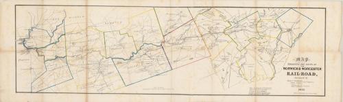
DescriptionMap of the Norwich and Worcester Railroad, from Norwich, Connecticut, to Worcester, Massachusetts, and the land surrounding it, oriented on the map so that north faces toward the top right corner. Each of the towns is outlined in what is probably watercolor, and features such as lakes, ponds, rivers, canals and local roads are depicted. Buildings are shown as small black squares. Quite a few cotton and wool factories are labeled along the Quinebaug River.
Label TextConstruction of the Norwich & Worcester Railroad began November 18, 1835, so the railroad did not yet exist when this map of its projected route was issued, presumably to attract investors and to increase public awareness of the project. One of the earliest Connecticut railroads, the Norwich & Worcester provided a convenient route between New York and Boston, avoiding the dangers of the Rhode Island coast and the passage around Cape Cod. Construction lasted almost five years; the railroad opened for business in 1840. Passengers and freight coming from the south arrived by steamboat in Norwich, Connecticut, located at the head of navigation on the Thames River. They then transferred to the railroad to continue their journey to Worcester and ultimately to Boston.
NotesCartographic Note: Scale: 3/4 inch equals 1 mileNorwich was a major transportation center in the nineteenth century, providing a convenient route from Boston to New York via the Norwich & Worcester Railroad, which connected with Long Island Sound steamboats at the Thames River steamboat landing. Irish labor was extensively used to build the railroad, which was incorporated in 1835 and completed and opened for service in 1840. James Pugh Kirkwood, a young Scottish emigrant, was employed as a surveyor on the project. Kirkwood went on to an illustrious career, working on many other railroads and waterworks throughout the eastern United States. The Connecticut Historical Society has two copies of Kirkwood's map of the Norwich & Worcester Railroad, one uncolored and one colored.
Status
Not on view