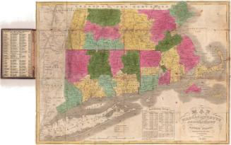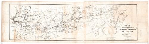
Map Exhibiting the route of the Norwich & Worcester Rail-Road
SurveyorSurveyed by
James Pugh Kirkwood
(American, 1807 - 1877)
SurveyorSurveyed by
William Lester Jr.
Date1835
MediumLithograph; black printer's ink on wove paper
DimensionsPrimary Dimensions (image height x width): 13 x 45in. (33 x 114.3cm)
Sheet (height x width): 15 x 51 3/4in. (38.1 x 131.4cm)
ClassificationsGraphics
Credit LineConnecticut Museum of Culture and History collection
Object number2012.312.142
DescriptionMap of the Norwich and Worcester Railroad, from Norwich, Connecticut, to Worcester, Massachusetts, and the land surrounding it, oriented on the map so that north faces toward the top right corner. Each of the towns is outlined in what is probably watercolor, and features such as lakes, ponds, rivers, canals and local roads are depicted. Buildings are shown as small black squares. Quite a few cotton and wool factories are labeled along the Quinebaug River.
Label TextThis map, based on surveys by the Scottish emigrant James Pugh Kirkwood and local surveyor William Lester, was produced in 1835, the year that construction on the Norwich & Worcester Railroad began. Even before Connecticut's first railroad, linking Stonington with Providence, Rhode Island, opened in 1837, businessmen in Norwich, Connecticut were already planning a railroad of their own, which would provide a direct link from from the steamship terminal in Norwich to Worcester, Massachusetts, then on to Boston. The Norwich & Worcester Railroad opened for business in 1840; its construction was interrupted when laborers working on the line, largely immigrant Irishmen, went on strike for higher wages..
NotesCartographic Note: Scale: 1 inch equals 1 mileNorwich was a major transportation center in the nineteenth century, providing a convenient route from Boston to New York via the Norwich & Worcester Railroad, which connected with Long Island Sound steamboats at the Thames River steamboat landing. Irish labor was extensively used to build the railroad, which was incorporated in 1835 and completed and opened for service in 1840. James Pugh Kirkwood, a young Scottish emigrant, was employed as a surveyor on the project. Kirkwood went on to an illustrious career, working on many other railroads and waterworks throughout the eastern United States. The Connecticut Historical Society has two copies of Kirkwood's map of the Norwich & Worcester Railroad, one uncolored and one colored.
Status
Not on view