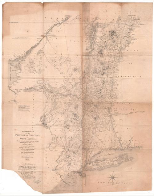
A Chorographical Map of the Province of New York in North America
PublisherPublished by
David Vaughan
After a work byAfter a work by
Claude Joseph Sauthier
(French, 1736 - 1802)
After a work byAfter a work published by
William Faden
(British, 1750 - 1836)
Date1849
MediumLithography; black printer's ink on wove paper
DimensionsPrimary Dimensions (image height x width): 37 7/8 x 29 1/2in. (96.2 x 74.9cm)
Sheet (height x width): 37 7/8 x 29 1/2in. (96.2 x 74.9cm)
Sheet (height x width): 37 7/8 x 29 1/2in. (96.2 x 74.9cm)
ClassificationsGraphics
Credit LineConnecticut Museum of Culture and History collection
DescriptionMap of New York, with Canada to the north; parts of New Hampshire, Massachusetts and Connecticut to the east; the Atlantic Ocean and New Jersey to the south; and Pennsylvania, the "Six Nations Indian Country" and Lake Ontario to the west. Relief is conveyed through hachures. Various lines are used to denote county boundaries and real property. Some railroads or other transportation lines appear to be marked but not labeled. Physical features include mountains, conveyed through hachure marks; lakes; rivers; and waterfalls.
Object number2012.312.140
NotesCartographic Note: About 7/8 inches equals 10 miles; 69 1/2 miles to a degreeOn View
Not on view


H. F. Sumner & Co.
1833


Thomas Sedgwick Steele
1881