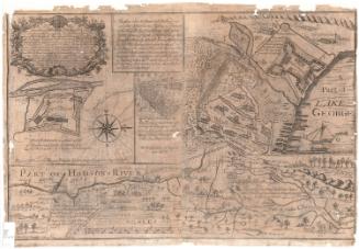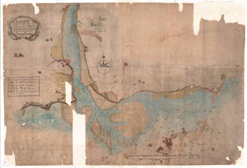
Capt. Parker's Chart of Saybrook Barr
SurveyorSurveyed by
Abner Parker
(American, active 1771)
Date1771
MediumEngraving; printer's ink on laid paper
Drawing; watercolor on laid paper
DimensionsPrimary Dimensions (image height x width): 26 7/8 x 39 5/8in. (68.3 x 100.6cm)
Sheet (height x width): 26 7/8 x 39 5/8in. (68.3 x 100.6cm)
ClassificationsGraphics
Credit LineConnecticut Museum of Culture and History collection
Object number2012.312.138
DescriptionChart of the Saybrook sandbar at the mouth of the Connecticut River where it meets the Long Island Sound, with routes around the shoals or sandbars. The banks of the river are dotted with houses and trees, and the governor's house, Hachets Pinte (Hatchett Point) and the "Old Dry Cow" are labeled. Four channels around the shoals are plotted with lines and labeled: the middle, east, west and south. At the far left of the map is Hen and Chickens reef. Depth measurements of some kind also appear on the map - there are numbers given that are followed by the letter "F," which may denote depth in fathoms, possibly feet. Other numbers, without qualifiers, are also marked, on both the water and shoals. Small "x"s and dots also appear on the shoals, with greater concentration around the edges than in the centers.
Label TextThe entrance to the Connecticut River has always been difficult to navigate. This is one of the reasons why the river remains largely undeveloped, in contrast to other rivers along the East Coast. Nevertheless, in the late 1700s, before the development of turnpikes and railroads, the river remained the main thoroughfare for most traffic, and the captains of the vessels sailing to and from Hartford and other river towns required an accurate guide to the treacherous sandbars at its mouth. Captain Abner Parker's manuscript map of Saybrook Bar was engraved by Abel Buell, and used as a practical aid to navigation by late eighteenth-century mariners. These maps were literally used up in the process and are extraordinarily rare today.
NotesCartographic Note: Scale: 640 rods equals 2 English miles [a rod is equal to 5 1/2 yards or 16 1/2 feet]Subject Note: The Saybrook Bar is a shifting sandbar or shoal at the mouth of the Connecticut River, with depths from 2 to 16 feet. It extends as far to the east as Hatchett Reef, and southeast from Saybrook Breakwater Lighthouse for 1 5/8 miles.
From Connecticut Place Names, p. 443.
Status
Not on view