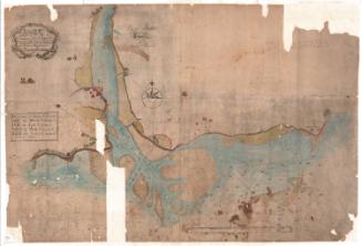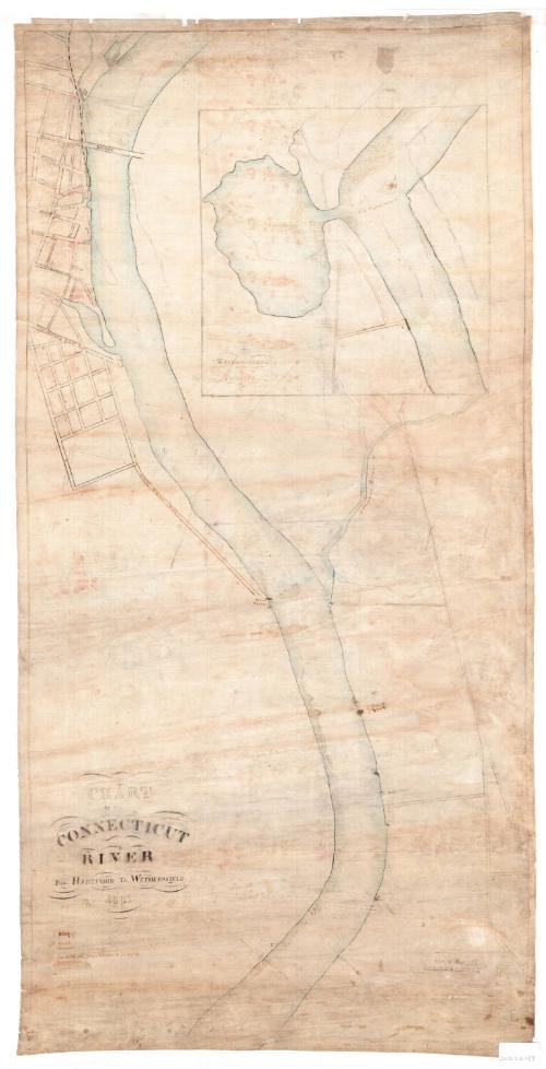
Chart of the Connecticut River from Hartford to Wethersfield
SurveyorSurveyed by
Unknown
DraftsmanDrawn by
Unknown
Date1867
MediumDrawing; black ink and watercolor on linen
DimensionsPrimary Dimensions (image height x width): 36 1/2 x 18 1/8in. (92.7 x 46cm)
Sheet (height x width): 37 1/4 x 18 7/8in. (94.6 x 47.9cm)
ClassificationsGraphics
Credit LineConnecticut Museum of Culture and History collection
Object number2012.312.137
DescriptionChart of the Connecticut River and the rocks, shoals and channels in it, from Hartford to Wethersfield, Connecticut. The streets of Hartford near the river are delineated and some of them are labeled. The Morgan Street bridge is also depicted. To the right of the map at the top, there is an inset showing Wethersfield Cove and the adjoining river. Below the title is a references list explaining the symbols used to depict rocks, shoals and channels.
Label TextThis detailed manuscript chart shows many obstacles to navigation in the short stretch of the Connecticut River between Hartford and Wethersfield, including sand shoals and rocks in midstream opposite Union Ferry at the end of Van Dyke Avenue, and extensive shoals and another large rock near the entrance to Wethersfield Cove. Upstream from the "Hartford Bridge," the old covered bridge that was located near the site of the modern Bulkeley Bridge, extensive sand shoals leave only a narrow channel. The difficulties in navigating the Connecticut River prevented the kind of extensive development that blighted the lower reaches of many major rivers and helped to preserve it relatively untouched to this day.
NotesCartographic Note: Scale: 1 inch equals 500 feetSubject Note: The river identified on this map as "Solomon's River," is--and was--more commonly known as the Hockanum River. Both names were in use during the nineteenth century, but the name "Hockanum River" was used more frequently.
Status
Not on view