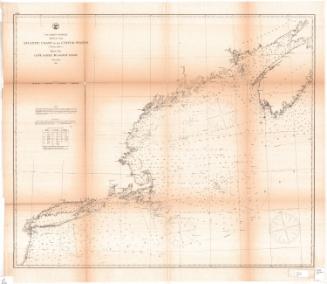
Blunt's New Chart of the North-Eastern Coast of North America
PublisherPublished by
Edmund March Blunt
(1770 - 1862)
PublisherPublished by
William Hooker
(American, 1782 - 1856)
Date1819
MediumEngraving; black printer's ink on paper
DimensionsPrimary Dimensions (image height x width): 38 1/4 x 62 3/8in. (97.2 x 158.4cm)
Sheet (height x width): 38 5/8 x 62 7/8in. (98.1 x 159.7cm)
Sheet (height x width): 38 5/8 x 62 7/8in. (98.1 x 159.7cm)
ClassificationsGraphics
Credit LineConnecticut Museum of Culture and History collection
DescriptionNautical chart of the Atlantic Ocean off the northeastern coast of North America, from New Jersey to Nova Scotia. The map is oriented east-west instead of north-south, with the land mass of North American to the east or top, the Bay of Fundy and Nova Scotia to the north or right, the ocean to the west or bottom and south or left. In the top right corner are insets of plans of Squam, Portland, Newport, Boston and Newbury Port Harbors, the last three of which include scales. Georges Bank is near the center of the chart. Along with depth measurements, shoals, banks, "green ooze," different colors and textures of sand, stones and pebbles are marked. There are two eight-point compass roses with a symbol marking north and four smaller 32-point compasses, one of which marks north.
Object number2012.312.136
NotesCartographic Note: Scale (main map): Sixty miles equals twenty leagues. The insets also have scale rulers, but only contain one unit of measurement, either statute or nautical miles.On View
Not on view