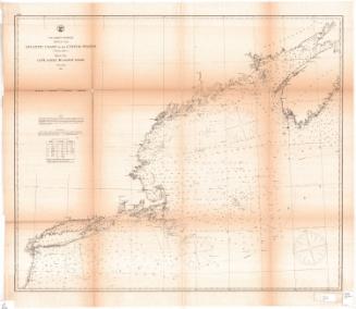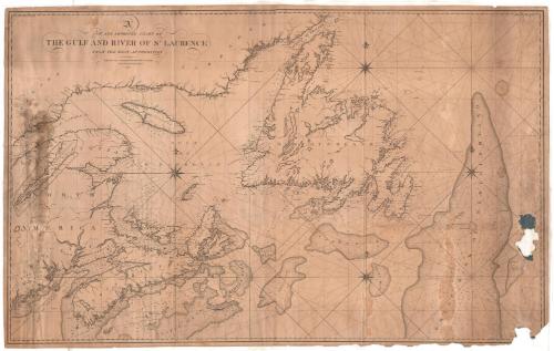
A New and Improved Chart of the Gulf and River of St. Laurence, from the best authorities
PrintmakerEngraved by
William Hooker
(American, 1782 - 1856)
PublisherPublished by
Edmund March Blunt
(1770 - 1862)
Date1827
MediumEngraving; black printer's ink on paper
DimensionsPrimary Dimensions (image height x width): 30 1/2 x 49in. (77.5 x 124.5cm)
Sheet (height x width): 31 1/4 x 49 3/4in. (79.4 x 126.4cm)
ClassificationsGraphics
Credit LineConnecticut Museum of Culture and History collection
Object number2012.312.134
DescriptionNautical chart, including depth measurements, of the St. Lawrence river and gulf, with Labrador to the north, the Great Bank of Newfoundland (Grand Banks) to the east, Nova Scotia and Sable Bank to the south, and New England, New Brunswick and Nova Scotia to the west. There is an inset of the St. Lawrence River from Quebec on the left. Lines of latitude and longitude are marked on the top, bottom and sides. Lighthouses are marked, as are areas with pebbles, shells and/or stones, or that make for rough fishing, on the Great Bank of Newfoundland. Four eight-point compass roses appear on the map, with three smaller compasses of 32 points.
Label TextThe large banks in the North Atlantic off Newfoundland and Labrador were among the richest and most productive fishing grounds in the world, but the region was notorious for dense fog and strong winds and had a long history of maritime disasters. Sailors needed accurate charts to help them navigate these dangerous waters and E. M. Blunt and William Hooker were the most important American publishers of such charts.
NotesCartographic Note: No scaleStatus
Not on view

Matthews-Northrup Company
1913